You are here: Home > Network List > TX - Texas Seismological Network Stations List
> Station WTFS Witchita Falls > Earthquake Result Viewer
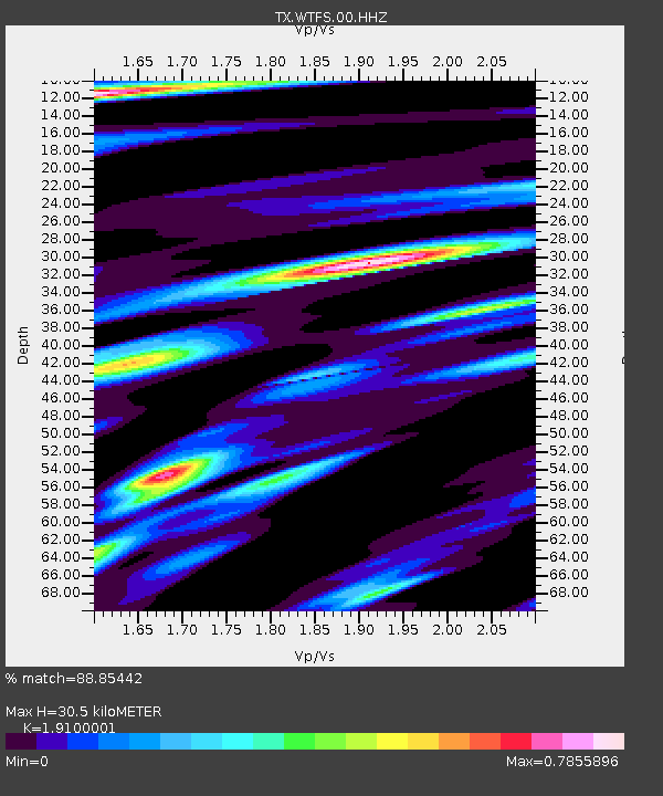
WTFS Witchita Falls - Earthquake Result Viewer
| Earthquake location: |
Easter Island Region |
| Earthquake latitude/longitude: |
-22.7/-112.3 |
| Earthquake time(UTC): |
2020/08/15 (228) 06:40:38 GMT |
| Earthquake Depth: |
10 km |
| Earthquake Magnitude: |
5.7 mww |
| Earthquake Catalog/Contributor: |
NEIC PDE/us |
|
| Network: |
TX Texas Seismological Network |
| Station: |
WTFS Witchita Falls |
| Lat/Lon: |
33.77 N/98.46 W |
| Elevation: |
277 m |
|
| Distance: |
57.7 deg |
| Az: |
13.649 deg |
| Baz: |
195.165 deg |
| Ray Param: |
0.06334609 |
| Estimated Moho Depth: |
30.5 km |
| Estimated Crust Vp/Vs: |
1.91 |
| Assumed Crust Vp: |
6.426 km/s |
| Estimated Crust Vs: |
3.364 km/s |
| Estimated Crust Poisson's Ratio: |
0.31 |
|
| Radial Match: |
88.85442 % |
| Radial Bump: |
400 |
| Transverse Match: |
61.04272 % |
| Transverse Bump: |
400 |
| SOD ConfigId: |
21709731 |
| Insert Time: |
2020-08-29 07:16:54.835 +0000 |
| GWidth: |
2.5 |
| Max Bumps: |
400 |
| Tol: |
0.001 |
|

Signal To Noise
| Channel | StoN | STA | LTA |
| TX:WTFS:00:HHZ:20200815T06:49:57.505005Z | 12.014709 | 9.421196E-7 | 7.841385E-8 |
| TX:WTFS:00:HH1:20200815T06:49:57.505005Z | 4.6970687 | 2.9062076E-7 | 6.187279E-8 |
| TX:WTFS:00:HH2:20200815T06:49:57.505005Z | 5.810857 | 3.619742E-7 | 6.229274E-8 |
| Arrivals |
| Ps | 4.5 SECOND |
| PpPs | 13 SECOND |
| PsPs/PpSs | 18 SECOND |


