You are here: Home > Network List > TX - Texas Seismological Network Stations List
> Station PB32 CR 111 > Earthquake Result Viewer
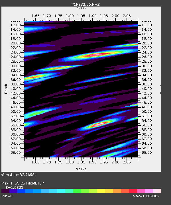
PB32 CR 111 - Earthquake Result Viewer
| Earthquake location: |
Easter Island Region |
| Earthquake latitude/longitude: |
-22.7/-112.3 |
| Earthquake time(UTC): |
2020/08/15 (228) 06:40:38 GMT |
| Earthquake Depth: |
10 km |
| Earthquake Magnitude: |
5.7 mww |
| Earthquake Catalog/Contributor: |
NEIC PDE/us |
|
| Network: |
TX Texas Seismological Network |
| Station: |
PB32 CR 111 |
| Lat/Lon: |
31.10 N/103.37 W |
| Elevation: |
861 m |
|
| Distance: |
54.2 deg |
| Az: |
9.464 deg |
| Baz: |
190.197 deg |
| Ray Param: |
0.06562679 |
| Estimated Moho Depth: |
55.25 km |
| Estimated Crust Vp/Vs: |
1.93 |
| Assumed Crust Vp: |
6.121 km/s |
| Estimated Crust Vs: |
3.167 km/s |
| Estimated Crust Poisson's Ratio: |
0.32 |
|
| Radial Match: |
82.76984 % |
| Radial Bump: |
400 |
| Transverse Match: |
73.18735 % |
| Transverse Bump: |
400 |
| SOD ConfigId: |
21709731 |
| Insert Time: |
2020-08-29 07:16:56.276 +0000 |
| GWidth: |
2.5 |
| Max Bumps: |
400 |
| Tol: |
0.001 |
|

Signal To Noise
| Channel | StoN | STA | LTA |
| TX:PB32:00:HHZ:20200815T06:49:32.469971Z | 7.6742263 | 1.0489818E-7 | 1.3668893E-8 |
| TX:PB32:00:HH1:20200815T06:49:32.469971Z | 3.6636207 | 8.706219E-8 | 2.3763974E-8 |
| TX:PB32:00:HH2:20200815T06:49:32.469971Z | 2.184934 | 4.9891266E-8 | 2.2834222E-8 |
| Arrivals |
| Ps | 8.8 SECOND |
| PpPs | 25 SECOND |
| PsPs/PpSs | 34 SECOND |


