You are here: Home > Network List > US - United States National Seismic Network Stations List
> Station DGMT Dagmar, Montana, USA > Earthquake Result Viewer
DGMT Dagmar, Montana, USA - Earthquake Result Viewer
*The percent match for this event was below the threshold and hence no stack was calculated.
| Earthquake location: |
Easter Island Region |
| Earthquake latitude/longitude: |
-22.7/-112.3 |
| Earthquake time(UTC): |
2020/08/15 (228) 06:40:38 GMT |
| Earthquake Depth: |
10 km |
| Earthquake Magnitude: |
5.7 mww |
| Earthquake Catalog/Contributor: |
NEIC PDE/us |
|
| Network: |
US United States National Seismic Network |
| Station: |
DGMT Dagmar, Montana, USA |
| Lat/Lon: |
48.47 N/104.20 W |
| Elevation: |
0.0 m |
|
| Distance: |
71.2 deg |
| Az: |
5.697 deg |
| Baz: |
187.918 deg |
| Ray Param: |
$rayparam |
*The percent match for this event was below the threshold and hence was not used in the summary stack. |
|
| Radial Match: |
84.71304 % |
| Radial Bump: |
400 |
| Transverse Match: |
63.73927 % |
| Transverse Bump: |
400 |
| SOD ConfigId: |
21709731 |
| Insert Time: |
2020-08-29 07:18:05.974 +0000 |
| GWidth: |
2.5 |
| Max Bumps: |
400 |
| Tol: |
0.001 |
|
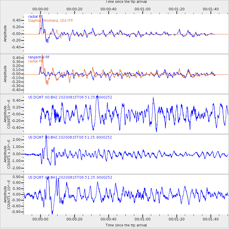
Signal To Noise
| Channel | StoN | STA | LTA |
| US:DGMT:00:BHZ:20200815T06:51:25.900025Z | 11.765605 | 1.0574673E-6 | 8.987785E-8 |
| US:DGMT:00:BH1:20200815T06:51:25.900025Z | 3.7901237 | 4.6043712E-7 | 1.214834E-7 |
| US:DGMT:00:BH2:20200815T06:51:25.900025Z | 2.2509668 | 3.300469E-7 | 1.466245E-7 |
| Arrivals |
| Ps | |
| PpPs | |
| PsPs/PpSs | |


