You are here: Home > Network List > IW - Intermountain West Stations List
> Station PLID Pearl Lake, Idaho, USA > Earthquake Result Viewer
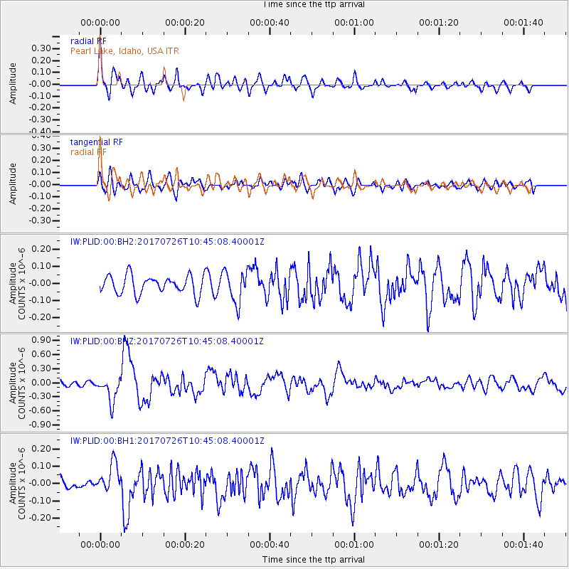
PLID Pearl Lake, Idaho, USA - Earthquake Result Viewer
*The percent match for this event was below the threshold and hence no stack was calculated.
| Earthquake location: |
Southeast Of Ryukyu Islands |
| Earthquake latitude/longitude: |
26.9/130.2 |
| Earthquake time(UTC): |
2017/07/26 (207) 10:32:57 GMT |
| Earthquake Depth: |
10 km |
| Earthquake Magnitude: |
5.9 Mww |
| Earthquake Catalog/Contributor: |
NEIC PDE/us |
|
| Network: |
IW Intermountain West |
| Station: |
PLID Pearl Lake, Idaho, USA |
| Lat/Lon: |
45.09 N/116.00 W |
| Elevation: |
2164 m |
|
| Distance: |
86.4 deg |
| Az: |
40.495 deg |
| Baz: |
305.068 deg |
| Ray Param: |
$rayparam |
*The percent match for this event was below the threshold and hence was not used in the summary stack. |
|
| Radial Match: |
73.84038 % |
| Radial Bump: |
400 |
| Transverse Match: |
66.473656 % |
| Transverse Bump: |
400 |
| SOD ConfigId: |
2140511 |
| Insert Time: |
2017-08-09 02:28:52.422 +0000 |
| GWidth: |
2.5 |
| Max Bumps: |
400 |
| Tol: |
0.001 |
|
Signal To Noise
| Channel | StoN | STA | LTA |
| IW:PLID:00:BHZ:20170726T10:45:08.40001Z | 5.6942587 | 2.7799277E-7 | 4.881984E-8 |
| IW:PLID:00:BH1:20170726T10:45:08.40001Z | 2.0954642 | 8.642007E-8 | 4.1241492E-8 |
| IW:PLID:00:BH2:20170726T10:45:08.40001Z | 1.8008801 | 9.57994E-8 | 5.3195883E-8 |
| Arrivals |
| Ps | |
| PpPs | |
| PsPs/PpSs | |


