You are here: Home > Network List > AU - Australian Seismological Centre Stations List
> Station LHI Lord Howe Island, Australia > Earthquake Result Viewer
LHI Lord Howe Island, Australia - Earthquake Result Viewer
| Earthquake location: |
Sea Of Okhotsk |
| Earthquake latitude/longitude: |
53.9/152.9 |
| Earthquake time(UTC): |
2008/07/05 (187) 02:12:04 GMT |
| Earthquake Depth: |
633 km |
| Earthquake Magnitude: |
6.8 MB, 7.7 MW, 7.7 MW |
| Earthquake Catalog/Contributor: |
WHDF/NEIC |
|
| Network: |
AU Australian Seismological Centre |
| Station: |
LHI Lord Howe Island, Australia |
| Lat/Lon: |
31.52 S/159.06 E |
| Elevation: |
74 m |
|
| Distance: |
85.2 deg |
| Az: |
174.71 deg |
| Baz: |
356.336 deg |
| Ray Param: |
0.043047037 |
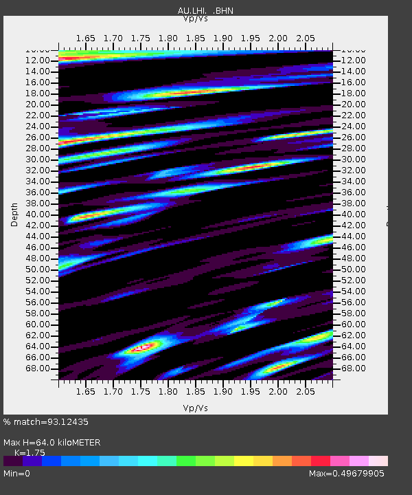
| Estimated Moho Depth: |
64.0 km |
| Estimated Crust Vp/Vs: |
1.75 |
| Assumed Crust Vp: |
4.157 km/s |
| Estimated Crust Vs: |
2.375 km/s |
| Estimated Crust Poisson's Ratio: |
0.26 |
|
| Radial Match: |
93.12435 % |
| Radial Bump: |
400 |
| Transverse Match: |
85.065315 % |
| Transverse Bump: |
400 |
| SOD ConfigId: |
2504 |
| Insert Time: |
2010-03-09 00:04:53.886 +0000 |
| GWidth: |
2.5 |
| Max Bumps: |
400 |
| Tol: |
0.001 |
|

Signal To Noise
| Channel | StoN | STA | LTA |
| AU:LHI: :BHN:20080705T02:23:04.644001Z | 3.3044944 | 3.1456802E-6 | 9.519399E-7 |
| AU:LHI: :BHE:20080705T02:23:04.644001Z | 1.6125549 | 1.0690406E-6 | 6.6294837E-7 |
| AU:LHI: :BHZ:20080705T02:23:04.644001Z | 1.7111481 | 1.6805276E-6 | 9.821052E-7 |
| Arrivals |
| Ps | 12 SECOND |
| PpPs | 42 SECOND |
| PsPs/PpSs | 54 SECOND |


