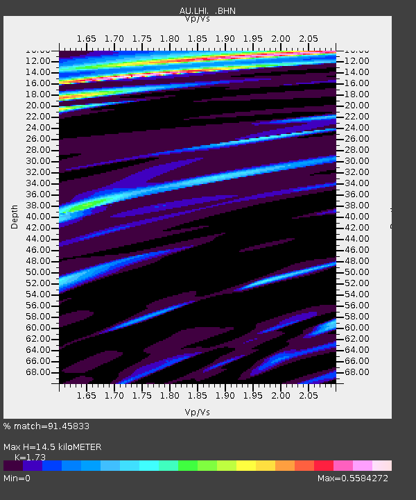
LHI Lord Howe Island, Australia - Earthquake Result Viewer

Earthquake location: Irian Jaya Region, Indonesia
Earthquake latitude/longitude: -0.7/133.3
Earthquake time(UTC): 2009/01/03 (003) 22:33:40 GMT
Earthquake Depth: 23 km
Earthquake Magnitude: 6.7 MB, 7.4 MS, 7.4 MW, 7.3 MW
Earthquake Catalog/Contributor: WHDF/NEIC
Network: AU Australian Seismological Centre
Station: LHI Lord Howe Island, Australia
Lat/Lon: 31.52 S/159.06 E
Elevation: 74 m
Distance: 39.2 deg
Az: 144.011 deg
Baz: 316.526 deg
Ray Param: 0.07510877
Estimated Moho Depth: 14.5 km
Estimated Crust Vp/Vs: 1.73
Assumed Crust Vp: 4.157 km/s
Estimated Crust Vs: 2.403 km/s
Estimated Crust Poisson's Ratio: 0.25
Radial Match: 91.45833 %
Radial Bump: 247
Transverse Match: 58.587963 %
Transverse Bump: 400
SOD ConfigId: 2834
Insert Time: 2010-03-09 00:04:57.430 +0000
GWidth: 2.5
Max Bumps: 400
Tol: 0.001

Signal To Noise

ChannelStoNSTALTA
AU:LHI: :BHN:20090103T22:40:35.520011Z7.8110211.04177225E-51.333721E-6
AU:LHI: :BHE:20090103T22:40:35.520011Z3.18007024.152566E-61.3058095E-6
AU:LHI: :BHZ:20090103T22:40:35.520011Z8.7703336.93351E-67.90564E-7
Arrivals
Ps2.6 SECOND
PpPs9.2 SECOND
PsPs/PpSs12 SECOND