You are here: Home > Network List > AU - Australian Seismological Centre Stations List
> Station LHI Lord Howe Island, Australia > Earthquake Result Viewer
LHI Lord Howe Island, Australia - Earthquake Result Viewer
| Earthquake location: |
Banda Sea |
| Earthquake latitude/longitude: |
-6.1/130.4 |
| Earthquake time(UTC): |
2009/10/24 (297) 14:40:43 GMT |
| Earthquake Depth: |
130 km |
| Earthquake Magnitude: |
6.7 MB, 6.9 MW, 6.9 MW |
| Earthquake Catalog/Contributor: |
WHDF/NEIC |
|
| Network: |
AU Australian Seismological Centre |
| Station: |
LHI Lord Howe Island, Australia |
| Lat/Lon: |
31.52 S/159.06 E |
| Elevation: |
74 m |
|
| Distance: |
36.8 deg |
| Az: |
136.891 deg |
| Baz: |
307.279 deg |
| Ray Param: |
0.076017566 |
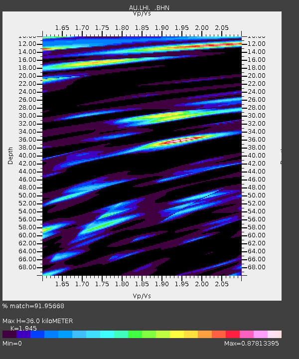
| Estimated Moho Depth: |
36.0 km |
| Estimated Crust Vp/Vs: |
1.95 |
| Assumed Crust Vp: |
4.157 km/s |
| Estimated Crust Vs: |
2.137 km/s |
| Estimated Crust Poisson's Ratio: |
0.32 |
|
| Radial Match: |
91.95668 % |
| Radial Bump: |
376 |
| Transverse Match: |
72.64057 % |
| Transverse Bump: |
400 |
| SOD ConfigId: |
2622 |
| Insert Time: |
2010-03-09 00:05:04.032 +0000 |
| GWidth: |
2.5 |
| Max Bumps: |
400 |
| Tol: |
0.001 |
|

Signal To Noise
| Channel | StoN | STA | LTA |
| AU:LHI: :BHN:20091024T14:47:09.019011Z | 10.277706 | 7.6161564E-6 | 7.410366E-7 |
| AU:LHI: :BHE:20091024T14:47:09.019011Z | 5.878448 | 2.9280889E-6 | 4.981058E-7 |
| AU:LHI: :BHZ:20091024T14:47:09.019011Z | 6.0366445 | 4.7406174E-6 | 7.853067E-7 |
| Arrivals |
| Ps | 8.4 SECOND |
| PpPs | 25 SECOND |
| PsPs/PpSs | 33 SECOND |


