You are here: Home > Network List > AU - Australian Seismological Centre Stations List
> Station LHI Lord Howe Island, Australia > Earthquake Result Viewer
LHI Lord Howe Island, Australia - Earthquake Result Viewer
| Earthquake location: |
South Of Mariana Islands |
| Earthquake latitude/longitude: |
12.5/143.2 |
| Earthquake time(UTC): |
2008/05/09 (130) 21:51:29 GMT |
| Earthquake Depth: |
76 km |
| Earthquake Magnitude: |
6.1 MB, 6.7 MW, 6.7 MW |
| Earthquake Catalog/Contributor: |
WHDF/NEIC |
|
| Network: |
AU Australian Seismological Centre |
| Station: |
LHI Lord Howe Island, Australia |
| Lat/Lon: |
31.52 S/159.06 E |
| Elevation: |
74 m |
|
| Distance: |
46.4 deg |
| Az: |
161.161 deg |
| Baz: |
338.332 deg |
| Ray Param: |
0.07046186 |
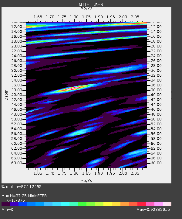
| Estimated Moho Depth: |
37.25 km |
| Estimated Crust Vp/Vs: |
1.79 |
| Assumed Crust Vp: |
4.157 km/s |
| Estimated Crust Vs: |
2.325 km/s |
| Estimated Crust Poisson's Ratio: |
0.27 |
|
| Radial Match: |
87.112495 % |
| Radial Bump: |
362 |
| Transverse Match: |
78.405075 % |
| Transverse Bump: |
399 |
| SOD ConfigId: |
2504 |
| Insert Time: |
2010-03-09 00:05:07.881 +0000 |
| GWidth: |
2.5 |
| Max Bumps: |
400 |
| Tol: |
0.001 |
|

Signal To Noise
| Channel | StoN | STA | LTA |
| AU:LHI: :BHN:20080509T21:59:17.818989Z | 9.161648 | 7.226304E-6 | 7.887559E-7 |
| AU:LHI: :BHE:20080509T21:59:17.818989Z | 4.1035933 | 2.6218372E-6 | 6.389125E-7 |
| AU:LHI: :BHZ:20080509T21:59:17.818989Z | 6.5480065 | 4.3582995E-6 | 6.655918E-7 |
| Arrivals |
| Ps | 7.2 SECOND |
| PpPs | 24 SECOND |
| PsPs/PpSs | 32 SECOND |


