You are here: Home > Network List > US - United States National Seismic Network Stations List
> Station ELK Elko, Nevada, USA > Earthquake Result Viewer
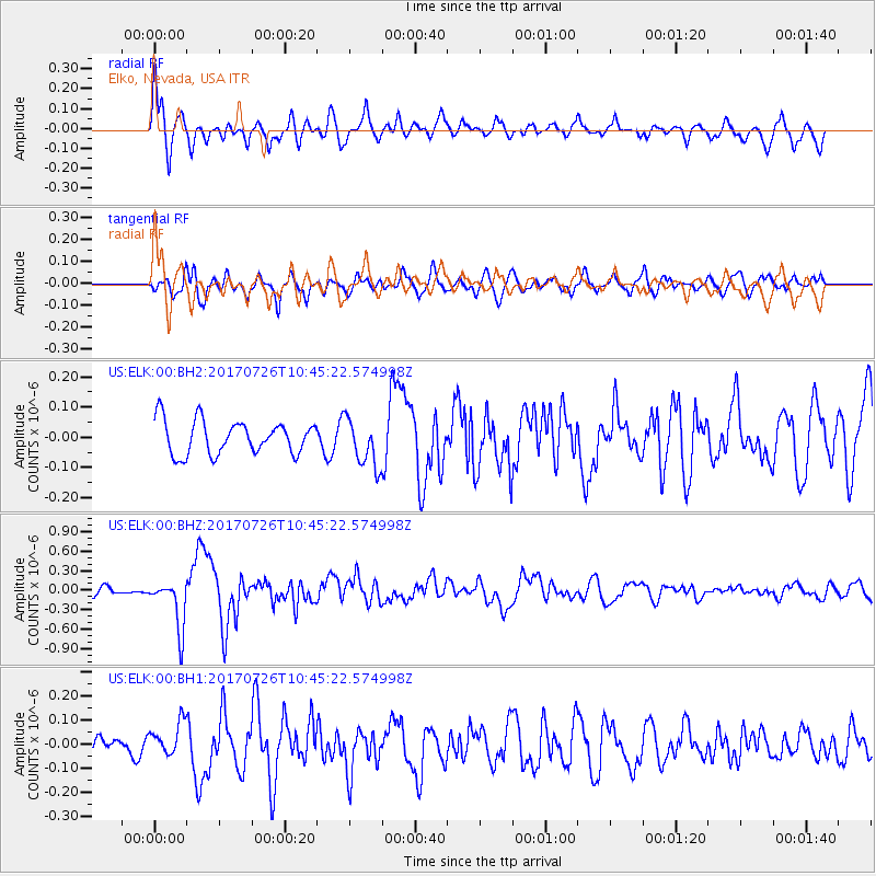
ELK Elko, Nevada, USA - Earthquake Result Viewer
*The percent match for this event was below the threshold and hence no stack was calculated.
| Earthquake location: |
Southeast Of Ryukyu Islands |
| Earthquake latitude/longitude: |
26.9/130.2 |
| Earthquake time(UTC): |
2017/07/26 (207) 10:32:57 GMT |
| Earthquake Depth: |
10 km |
| Earthquake Magnitude: |
5.9 Mww |
| Earthquake Catalog/Contributor: |
NEIC PDE/us |
|
| Network: |
US United States National Seismic Network |
| Station: |
ELK Elko, Nevada, USA |
| Lat/Lon: |
40.74 N/115.24 W |
| Elevation: |
2210 m |
|
| Distance: |
89.4 deg |
| Az: |
43.711 deg |
| Baz: |
305.703 deg |
| Ray Param: |
$rayparam |
*The percent match for this event was below the threshold and hence was not used in the summary stack. |
|
| Radial Match: |
74.09246 % |
| Radial Bump: |
400 |
| Transverse Match: |
53.81505 % |
| Transverse Bump: |
400 |
| SOD ConfigId: |
2140511 |
| Insert Time: |
2017-08-09 02:30:29.894 +0000 |
| GWidth: |
2.5 |
| Max Bumps: |
400 |
| Tol: |
0.001 |
|
Signal To Noise
| Channel | StoN | STA | LTA |
| US:ELK:00:BHZ:20170726T10:45:22.574998Z | 5.5313077 | 3.8264716E-7 | 6.917843E-8 |
| US:ELK:00:BH1:20170726T10:45:22.574998Z | 0.7883129 | 6.6913174E-8 | 8.4881485E-8 |
| US:ELK:00:BH2:20170726T10:45:22.574998Z | 1.4431119 | 7.97234E-8 | 5.5244087E-8 |
| Arrivals |
| Ps | |
| PpPs | |
| PsPs/PpSs | |


