You are here: Home > Network List > AU - Australian Seismological Centre Stations List
> Station MANU Manus Island, Papau New Guinea > Earthquake Result Viewer
MANU Manus Island, Papau New Guinea - Earthquake Result Viewer
| Earthquake location: |
Near S. Coast Of Honshu, Japan |
| Earthquake latitude/longitude: |
33.2/137.9 |
| Earthquake time(UTC): |
2009/08/09 (221) 10:55:55 GMT |
| Earthquake Depth: |
297 km |
| Earthquake Magnitude: |
6.5 MB, 7.1 MW, 7.1 MW |
| Earthquake Catalog/Contributor: |
WHDF/NEIC |
|
| Network: |
AU Australian Seismological Centre |
| Station: |
MANU Manus Island, Papau New Guinea |
| Lat/Lon: |
2.04 S/147.37 E |
| Elevation: |
142 m |
|
| Distance: |
36.1 deg |
| Az: |
163.887 deg |
| Baz: |
346.531 deg |
| Ray Param: |
0.075656764 |
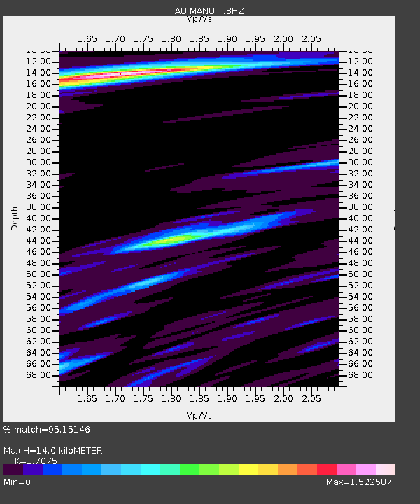
| Estimated Moho Depth: |
14.0 km |
| Estimated Crust Vp/Vs: |
1.71 |
| Assumed Crust Vp: |
4.082 km/s |
| Estimated Crust Vs: |
2.391 km/s |
| Estimated Crust Poisson's Ratio: |
0.24 |
|
| Radial Match: |
95.15146 % |
| Radial Bump: |
340 |
| Transverse Match: |
80.58993 % |
| Transverse Bump: |
400 |
| SOD ConfigId: |
2622 |
| Insert Time: |
2010-03-09 00:05:31.837 +0000 |
| GWidth: |
2.5 |
| Max Bumps: |
400 |
| Tol: |
0.001 |
|

Signal To Noise
| Channel | StoN | STA | LTA |
| AU:MANU: :BHZ:20090809T11:01:59.645004Z | 37.309593 | 1.1734901E-5 | 3.145277E-7 |
| AU:MANU: :BHN:20090809T11:01:59.645004Z | 15.86421 | 6.487246E-6 | 4.0892337E-7 |
| AU:MANU: :BHE:20090809T11:01:59.645004Z | 4.801099 | 2.1399237E-6 | 4.4571536E-7 |
| Arrivals |
| Ps | 2.5 SECOND |
| PpPs | 9.0 SECOND |
| PsPs/PpSs | 12 SECOND |


