You are here: Home > Network List > AU - Australian Seismological Centre Stations List
> Station MANU Manus Island, Papau New Guinea > Earthquake Result Viewer
MANU Manus Island, Papau New Guinea - Earthquake Result Viewer
| Earthquake location: |
Samoa Islands Region |
| Earthquake latitude/longitude: |
-14.9/-174.8 |
| Earthquake time(UTC): |
2009/10/14 (287) 18:00:21 GMT |
| Earthquake Depth: |
10 km |
| Earthquake Magnitude: |
5.7 MB, 6.0 MS, 6.3 MW, 6.2 MW |
| Earthquake Catalog/Contributor: |
WHDF/NEIC |
|
| Network: |
AU Australian Seismological Centre |
| Station: |
MANU Manus Island, Papau New Guinea |
| Lat/Lon: |
2.04 S/147.37 E |
| Elevation: |
142 m |
|
| Distance: |
39.4 deg |
| Az: |
285.303 deg |
| Baz: |
111.082 deg |
| Ray Param: |
0.07498638 |
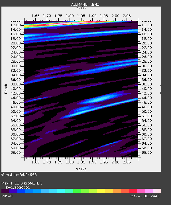
| Estimated Moho Depth: |
11.0 km |
| Estimated Crust Vp/Vs: |
1.81 |
| Assumed Crust Vp: |
4.082 km/s |
| Estimated Crust Vs: |
2.262 km/s |
| Estimated Crust Poisson's Ratio: |
0.28 |
|
| Radial Match: |
86.94963 % |
| Radial Bump: |
338 |
| Transverse Match: |
77.62894 % |
| Transverse Bump: |
400 |
| SOD ConfigId: |
2622 |
| Insert Time: |
2010-03-09 00:05:35.399 +0000 |
| GWidth: |
2.5 |
| Max Bumps: |
400 |
| Tol: |
0.001 |
|

Signal To Noise
| Channel | StoN | STA | LTA |
| AU:MANU: :BHZ:20091014T18:07:21.043987Z | 3.334377 | 7.1314577E-7 | 2.1387676E-7 |
| AU:MANU: :BHN:20091014T18:07:21.043987Z | 1.1232543 | 3.33548E-7 | 2.969479E-7 |
| AU:MANU: :BHE:20091014T18:07:21.043987Z | 1.2988214 | 2.1155422E-7 | 1.6288168E-7 |
| Arrivals |
| Ps | 2.2 SECOND |
| PpPs | 7.4 SECOND |
| PsPs/PpSs | 9.6 SECOND |


