You are here: Home > Network List > US - United States National Seismic Network Stations List
> Station WUAZ Wupatki, Arizona, USA > Earthquake Result Viewer
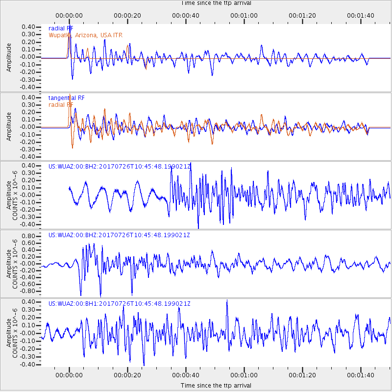
WUAZ Wupatki, Arizona, USA - Earthquake Result Viewer
*The percent match for this event was below the threshold and hence no stack was calculated.
| Earthquake location: |
Southeast Of Ryukyu Islands |
| Earthquake latitude/longitude: |
26.9/130.2 |
| Earthquake time(UTC): |
2017/07/26 (207) 10:32:57 GMT |
| Earthquake Depth: |
10 km |
| Earthquake Magnitude: |
5.9 Mww |
| Earthquake Catalog/Contributor: |
NEIC PDE/us |
|
| Network: |
US United States National Seismic Network |
| Station: |
WUAZ Wupatki, Arizona, USA |
| Lat/Lon: |
35.52 N/111.37 W |
| Elevation: |
1592 m |
|
| Distance: |
95.0 deg |
| Az: |
46.058 deg |
| Baz: |
307.994 deg |
| Ray Param: |
$rayparam |
*The percent match for this event was below the threshold and hence was not used in the summary stack. |
|
| Radial Match: |
62.795303 % |
| Radial Bump: |
400 |
| Transverse Match: |
67.26536 % |
| Transverse Bump: |
400 |
| SOD ConfigId: |
2140511 |
| Insert Time: |
2017-08-09 02:31:10.157 +0000 |
| GWidth: |
2.5 |
| Max Bumps: |
400 |
| Tol: |
0.001 |
|
Signal To Noise
| Channel | StoN | STA | LTA |
| US:WUAZ:00:BHZ:20170726T10:45:48.199021Z | 4.043836 | 2.991724E-7 | 7.398233E-8 |
| US:WUAZ:00:BH1:20170726T10:45:48.199021Z | 0.9449928 | 6.8064445E-8 | 7.202642E-8 |
| US:WUAZ:00:BH2:20170726T10:45:48.199021Z | 0.96769917 | 9.890431E-8 | 1.0220564E-7 |
| Arrivals |
| Ps | |
| PpPs | |
| PsPs/PpSs | |


