You are here: Home > Network List > AU - Australian Seismological Centre Stations List
> Station MAW Mawson, Antarctica > Earthquake Result Viewer
MAW Mawson, Antarctica - Earthquake Result Viewer
| Earthquake location: |
Tonga Islands |
| Earthquake latitude/longitude: |
-21.9/-173.8 |
| Earthquake time(UTC): |
2008/10/19 (293) 05:10:33 GMT |
| Earthquake Depth: |
29 km |
| Earthquake Magnitude: |
6.8 MB, 7.0 MS, 6.9 MW, 6.9 MW |
| Earthquake Catalog/Contributor: |
WHDF/NEIC |
|
| Network: |
AU Australian Seismological Centre |
| Station: |
MAW Mawson, Antarctica |
| Lat/Lon: |
67.60 S/62.87 E |
| Elevation: |
12 m |
|
| Distance: |
81.6 deg |
| Az: |
198.889 deg |
| Baz: |
128.299 deg |
| Ray Param: |
0.047452614 |
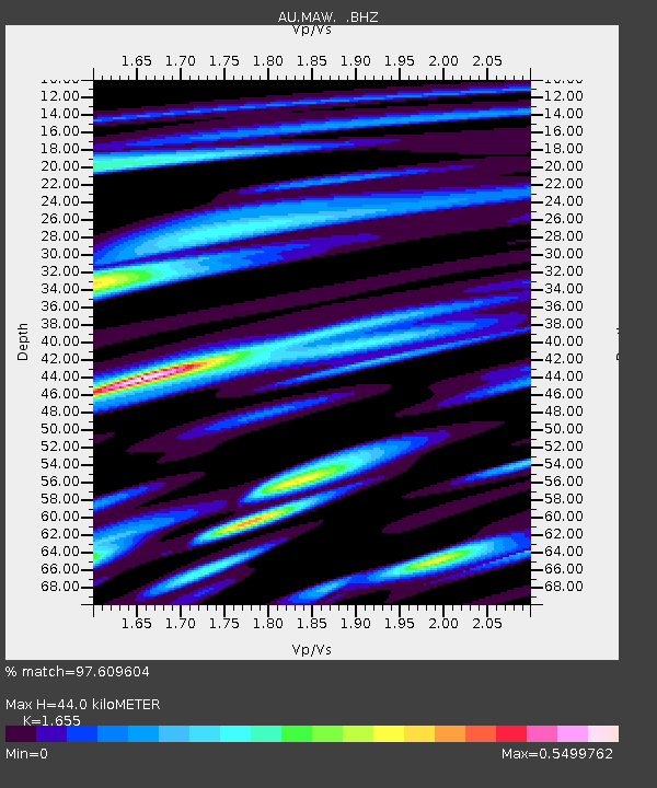
| Estimated Moho Depth: |
44.0 km |
| Estimated Crust Vp/Vs: |
1.65 |
| Assumed Crust Vp: |
6.508 km/s |
| Estimated Crust Vs: |
3.932 km/s |
| Estimated Crust Poisson's Ratio: |
0.21 |
|
| Radial Match: |
97.609604 % |
| Radial Bump: |
400 |
| Transverse Match: |
92.96112 % |
| Transverse Bump: |
400 |
| SOD ConfigId: |
2556 |
| Insert Time: |
2010-03-09 00:06:09.606 +0000 |
| GWidth: |
2.5 |
| Max Bumps: |
400 |
| Tol: |
0.001 |
|

Signal To Noise
| Channel | StoN | STA | LTA |
| AU:MAW: :BHZ:20081019T05:22:17.662014Z | 98.905556 | 1.1668857E-6 | 1.17979795E-8 |
| AU:MAW: :BHN:20081019T05:22:17.662014Z | 27.699255 | 3.0168408E-7 | 1.0891415E-8 |
| AU:MAW: :BHE:20081019T05:22:17.662014Z | 19.857817 | 3.588525E-7 | 1.8071097E-8 |
| Arrivals |
| Ps | 4.6 SECOND |
| PpPs | 17 SECOND |
| PsPs/PpSs | 22 SECOND |


