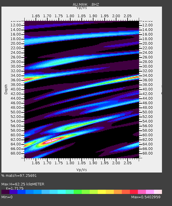
MAW Mawson, Antarctica - Earthquake Result Viewer

Earthquake location: Minahassa Peninsula, Sulawesi
Earthquake latitude/longitude: 1.3/122.1
Earthquake time(UTC): 2008/11/16 (321) 17:02:32 GMT
Earthquake Depth: 30 km
Earthquake Magnitude: 6.5 MB, 7.0 MS, 7.3 MW, 7.3 MW
Earthquake Catalog/Contributor: WHDF/NEIC
Network: AU Australian Seismological Centre
Station: MAW Mawson, Antarctica
Lat/Lon: 67.60 S/62.87 E
Elevation: 12 m
Distance: 79.9 deg
Az: 199.537 deg
Baz: 60.751 deg
Ray Param: 0.048618753
Estimated Moho Depth: 62.25 km
Estimated Crust Vp/Vs: 1.72
Assumed Crust Vp: 6.508 km/s
Estimated Crust Vs: 3.789 km/s
Estimated Crust Poisson's Ratio: 0.24
Radial Match: 97.25691 %
Radial Bump: 330
Transverse Match: 91.68894 %
Transverse Bump: 400
SOD ConfigId: 2658
Insert Time: 2010-03-09 00:06:16.426 +0000
GWidth: 2.5
Max Bumps: 400
Tol: 0.001

Signal To Noise

ChannelStoNSTALTA
AU:MAW: :BHZ:20081116T17:14:07.312Z41.238271.3206303E-63.2024385E-8
AU:MAW: :BHN:20081116T17:14:07.312Z7.7828453.176284E-74.0811347E-8
AU:MAW: :BHE:20081116T17:14:07.312Z16.9451264.8121933E-72.8398688E-8
Arrivals
Ps7.1 SECOND
PpPs25 SECOND
PsPs/PpSs32 SECOND