You are here: Home > Network List > C0 - Colorado Geological Survey Seismic Network Stations List
> Station T25A Trinidad, CO > Earthquake Result Viewer
T25A Trinidad, CO - Earthquake Result Viewer
| Earthquake location: |
Fox Islands, Aleutian Islands |
| Earthquake latitude/longitude: |
51.7/-171.2 |
| Earthquake time(UTC): |
2020/08/16 (229) 20:05:57 GMT |
| Earthquake Depth: |
43 km |
| Earthquake Magnitude: |
5.7 Mi |
| Earthquake Catalog/Contributor: |
NEIC PDE/at |
|
| Network: |
C0 Colorado Geological Survey Seismic Network |
| Station: |
T25A Trinidad, CO |
| Lat/Lon: |
37.08 N/104.25 W |
| Elevation: |
1800 m |
|
| Distance: |
48.3 deg |
| Az: |
80.082 deg |
| Baz: |
309.935 deg |
| Ray Param: |
0.0693333 |
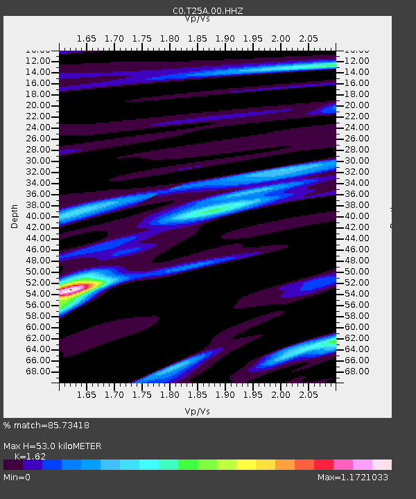
| Estimated Moho Depth: |
53.0 km |
| Estimated Crust Vp/Vs: |
1.62 |
| Assumed Crust Vp: |
6.316 km/s |
| Estimated Crust Vs: |
3.898 km/s |
| Estimated Crust Poisson's Ratio: |
0.19 |
|
| Radial Match: |
85.73418 % |
| Radial Bump: |
347 |
| Transverse Match: |
81.14291 % |
| Transverse Bump: |
351 |
| SOD ConfigId: |
21709731 |
| Insert Time: |
2020-08-30 20:08:52.875 +0000 |
| GWidth: |
2.5 |
| Max Bumps: |
400 |
| Tol: |
0.001 |
|

Signal To Noise
| Channel | StoN | STA | LTA |
| C0:T25A:00:HHZ:20200816T20:14:02.670013Z | 7.5444837 | 4.3796504E-7 | 5.805103E-8 |
| C0:T25A:00:HHN:20200816T20:14:02.670013Z | 1.6774635 | 1.4842173E-7 | 8.847985E-8 |
| C0:T25A:00:HHE:20200816T20:14:02.670013Z | 1.8591691 | 1.3261842E-7 | 7.1332096E-8 |
| Arrivals |
| Ps | 5.5 SECOND |
| PpPs | 21 SECOND |
| PsPs/PpSs | 26 SECOND |


