You are here: Home > Network List > CI - Caltech Regional Seismic Network Stations List
> Station MPP McPhearson Peak > Earthquake Result Viewer
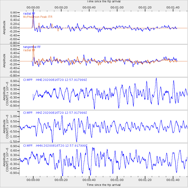
MPP McPhearson Peak - Earthquake Result Viewer
*The percent match for this event was below the threshold and hence no stack was calculated.
| Earthquake location: |
Fox Islands, Aleutian Islands |
| Earthquake latitude/longitude: |
51.7/-171.2 |
| Earthquake time(UTC): |
2020/08/16 (229) 20:05:57 GMT |
| Earthquake Depth: |
43 km |
| Earthquake Magnitude: |
5.7 Mi |
| Earthquake Catalog/Contributor: |
NEIC PDE/at |
|
| Network: |
CI Caltech Regional Seismic Network |
| Station: |
MPP McPhearson Peak |
| Lat/Lon: |
34.89 N/119.81 W |
| Elevation: |
1739 m |
|
| Distance: |
40.1 deg |
| Az: |
94.196 deg |
| Baz: |
310.957 deg |
| Ray Param: |
$rayparam |
*The percent match for this event was below the threshold and hence was not used in the summary stack. |
|
| Radial Match: |
73.98937 % |
| Radial Bump: |
400 |
| Transverse Match: |
60.883953 % |
| Transverse Bump: |
400 |
| SOD ConfigId: |
21709731 |
| Insert Time: |
2020-08-30 20:11:00.145 +0000 |
| GWidth: |
2.5 |
| Max Bumps: |
400 |
| Tol: |
0.001 |
|
Signal To Noise
| Channel | StoN | STA | LTA |
| CI:MPP: :HHZ:20200816T20:12:57.917999Z | 2.5758731 | 4.4661346E-7 | 1.7338333E-7 |
| CI:MPP: :HHN:20200816T20:12:57.917999Z | 1.5923005 | 3.8610375E-7 | 2.424817E-7 |
| CI:MPP: :HHE:20200816T20:12:57.917999Z | 0.9624478 | 2.1419761E-7 | 2.2255504E-7 |
| Arrivals |
| Ps | |
| PpPs | |
| PsPs/PpSs | |


