You are here: Home > Network List > CI - Caltech Regional Seismic Network Stations List
> Station TUQ Turquiose Mountain, Baker, CA, USA > Earthquake Result Viewer
TUQ Turquiose Mountain, Baker, CA, USA - Earthquake Result Viewer
| Earthquake location: |
Fox Islands, Aleutian Islands |
| Earthquake latitude/longitude: |
51.7/-171.2 |
| Earthquake time(UTC): |
2020/08/16 (229) 20:05:57 GMT |
| Earthquake Depth: |
43 km |
| Earthquake Magnitude: |
5.7 Mi |
| Earthquake Catalog/Contributor: |
NEIC PDE/at |
|
| Network: |
CI Caltech Regional Seismic Network |
| Station: |
TUQ Turquiose Mountain, Baker, CA, USA |
| Lat/Lon: |
35.44 N/115.92 W |
| Elevation: |
1350 m |
|
| Distance: |
42.2 deg |
| Az: |
90.41 deg |
| Baz: |
310.334 deg |
| Ray Param: |
0.07325077 |
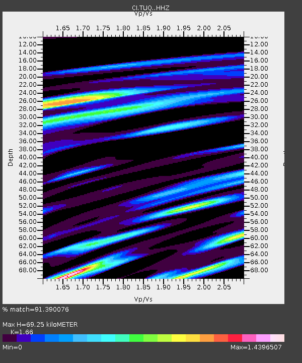
| Estimated Moho Depth: |
69.25 km |
| Estimated Crust Vp/Vs: |
1.66 |
| Assumed Crust Vp: |
6.276 km/s |
| Estimated Crust Vs: |
3.781 km/s |
| Estimated Crust Poisson's Ratio: |
0.22 |
|
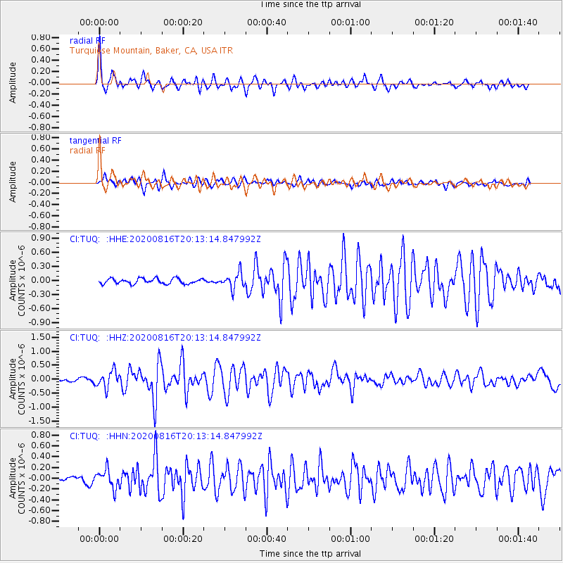
| Radial Match: |
91.390076 % |
| Radial Bump: |
400 |
| Transverse Match: |
80.617256 % |
| Transverse Bump: |
400 |
| SOD ConfigId: |
21709731 |
| Insert Time: |
2020-08-30 20:11:33.223 +0000 |
| GWidth: |
2.5 |
| Max Bumps: |
400 |
| Tol: |
0.001 |
|
Signal To Noise
| Channel | StoN | STA | LTA |
| CI:TUQ: :HHZ:20200816T20:13:14.847992Z | 3.8331065 | 2.9958187E-7 | 7.815642E-8 |
| CI:TUQ: :HHN:20200816T20:13:14.847992Z | 2.6104367 | 1.7760901E-7 | 6.803805E-8 |
| CI:TUQ: :HHE:20200816T20:13:14.847992Z | 3.058366 | 1.7023652E-7 | 5.5662568E-8 |
| Arrivals |
| Ps | 7.8 SECOND |
| PpPs | 27 SECOND |
| PsPs/PpSs | 35 SECOND |


