You are here: Home > Network List > N4 - Central and EAstern US Network Stations List
> Station SUSD Miller, SD, USA > Earthquake Result Viewer
SUSD Miller, SD, USA - Earthquake Result Viewer
| Earthquake location: |
Fox Islands, Aleutian Islands |
| Earthquake latitude/longitude: |
51.7/-171.2 |
| Earthquake time(UTC): |
2020/08/16 (229) 20:05:57 GMT |
| Earthquake Depth: |
43 km |
| Earthquake Magnitude: |
5.7 Mi |
| Earthquake Catalog/Contributor: |
NEIC PDE/at |
|
| Network: |
N4 Central and EAstern US Network |
| Station: |
SUSD Miller, SD, USA |
| Lat/Lon: |
44.44 N/98.96 W |
| Elevation: |
520 m |
|
| Distance: |
47.0 deg |
| Az: |
68.89 deg |
| Baz: |
305.833 deg |
| Ray Param: |
0.07018943 |
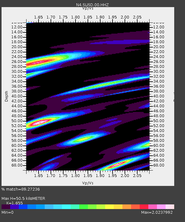
| Estimated Moho Depth: |
50.5 km |
| Estimated Crust Vp/Vs: |
1.65 |
| Assumed Crust Vp: |
6.53 km/s |
| Estimated Crust Vs: |
3.946 km/s |
| Estimated Crust Poisson's Ratio: |
0.21 |
|
| Radial Match: |
89.27236 % |
| Radial Bump: |
293 |
| Transverse Match: |
78.955696 % |
| Transverse Bump: |
352 |
| SOD ConfigId: |
21709731 |
| Insert Time: |
2020-08-30 20:20:38.611 +0000 |
| GWidth: |
2.5 |
| Max Bumps: |
400 |
| Tol: |
0.001 |
|

Signal To Noise
| Channel | StoN | STA | LTA |
| N4:SUSD:00:HHZ:20200816T20:13:53.329987Z | 3.738801 | 5.1253016E-7 | 1.3708409E-7 |
| N4:SUSD:00:HH1:20200816T20:13:53.329987Z | 1.4397545 | 3.6463234E-7 | 2.5326008E-7 |
| N4:SUSD:00:HH2:20200816T20:13:53.329987Z | 2.7625785 | 5.6233347E-7 | 2.0355382E-7 |
| Arrivals |
| Ps | 5.4 SECOND |
| PpPs | 19 SECOND |
| PsPs/PpSs | 25 SECOND |


