You are here: Home > Network List > TJ - Tajikistan National Seismic Network Stations List
> Station SHAA Shaartuz, Tajikistan > Earthquake Result Viewer
SHAA Shaartuz, Tajikistan - Earthquake Result Viewer

| Earthquake location: |
Fox Islands, Aleutian Islands |
| Earthquake latitude/longitude: |
51.7/-171.2 |
| Earthquake time(UTC): |
2020/08/16 (229) 20:05:57 GMT |
| Earthquake Depth: |
43 km |
| Earthquake Magnitude: |
5.7 Mi |
| Earthquake Catalog/Contributor: |
NEIC PDE/at |
|
| Network: |
TJ Tajikistan National Seismic Network |
| Station: |
SHAA Shaartuz, Tajikistan |
| Lat/Lon: |
37.56 N/68.12 E |
| Elevation: |
868 m |
|
| Distance: |
77.1 deg |
| Az: |
315.492 deg |
| Baz: |
33.307 deg |
| Ray Param: |
0.050456237 |
| Estimated Moho Depth: |
37.75 km |
| Estimated Crust Vp/Vs: |
1.74 |
| Assumed Crust Vp: |
6.213 km/s |
| Estimated Crust Vs: |
3.571 km/s |
| Estimated Crust Poisson's Ratio: |
0.25 |
|
| Radial Match: |
80.6587 % |
| Radial Bump: |
400 |
| Transverse Match: |
79.34453 % |
| Transverse Bump: |
400 |
| SOD ConfigId: |
21709731 |
| Insert Time: |
2020-08-30 20:27:09.407 +0000 |
| GWidth: |
2.5 |
| Max Bumps: |
400 |
| Tol: |
0.001 |
|
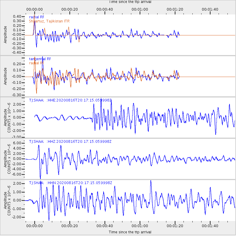
Signal To Noise
| Channel | StoN | STA | LTA |
| TJ:SHAA: :HHZ:20200816T20:17:15.059998Z | 16.258608 | 2.8592835E-6 | 1.7586275E-7 |
| TJ:SHAA: :HHN:20200816T20:17:15.059998Z | 4.2633886 | 9.1168863E-7 | 2.1384133E-7 |
| TJ:SHAA: :HHE:20200816T20:17:15.059998Z | 3.4776087 | 7.6273693E-7 | 2.19328E-7 |
| Arrivals |
| Ps | 4.6 SECOND |
| PpPs | 16 SECOND |
| PsPs/PpSs | 21 SECOND |


