You are here: Home > Network List > US - United States National Seismic Network Stations List
> Station HAWA Hanford, Washington, USA > Earthquake Result Viewer
HAWA Hanford, Washington, USA - Earthquake Result Viewer
*The percent match for this event was below the threshold and hence no stack was calculated.
| Earthquake location: |
Fox Islands, Aleutian Islands |
| Earthquake latitude/longitude: |
51.7/-171.2 |
| Earthquake time(UTC): |
2020/08/16 (229) 20:05:57 GMT |
| Earthquake Depth: |
43 km |
| Earthquake Magnitude: |
5.7 Mi |
| Earthquake Catalog/Contributor: |
NEIC PDE/at |
|
| Network: |
US United States National Seismic Network |
| Station: |
HAWA Hanford, Washington, USA |
| Lat/Lon: |
46.39 N/119.53 W |
| Elevation: |
364 m |
|
| Distance: |
33.7 deg |
| Az: |
78.214 deg |
| Baz: |
298.308 deg |
| Ray Param: |
$rayparam |
*The percent match for this event was below the threshold and hence was not used in the summary stack. |
|
| Radial Match: |
78.704056 % |
| Radial Bump: |
400 |
| Transverse Match: |
69.8142 % |
| Transverse Bump: |
400 |
| SOD ConfigId: |
21709731 |
| Insert Time: |
2020-08-30 20:29:19.110 +0000 |
| GWidth: |
2.5 |
| Max Bumps: |
400 |
| Tol: |
0.001 |
|
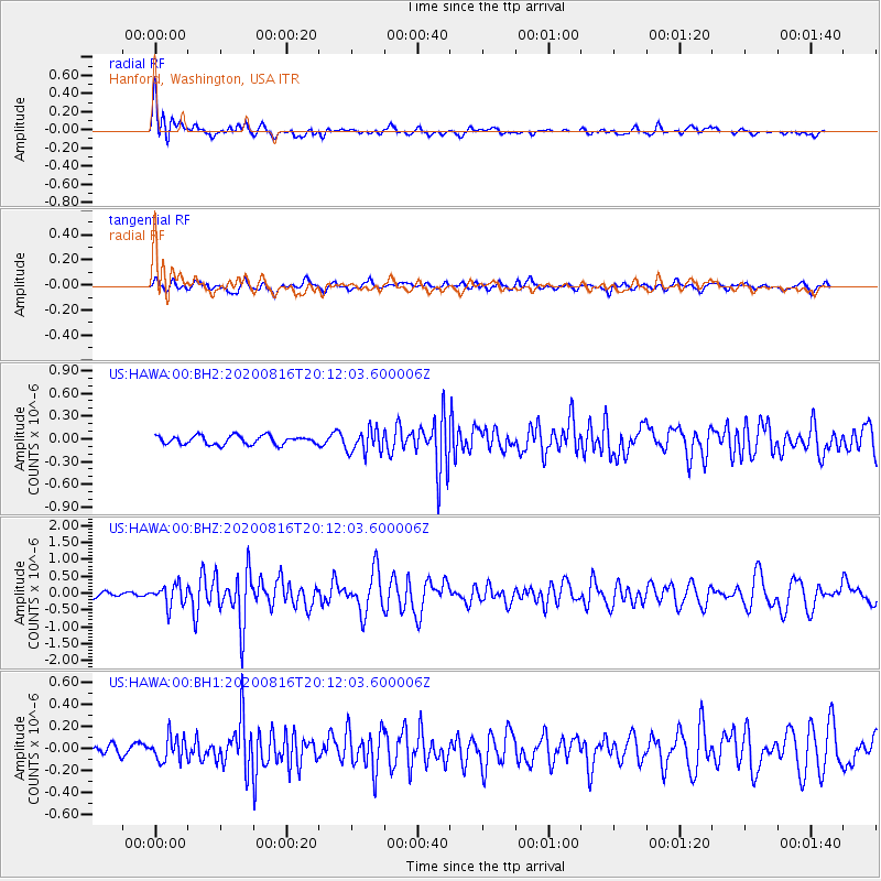
Signal To Noise
| Channel | StoN | STA | LTA |
| US:HAWA:00:BHZ:20200816T20:12:03.600006Z | 3.4475455 | 3.0903772E-7 | 8.9639926E-8 |
| US:HAWA:00:BH1:20200816T20:12:03.600006Z | 1.6066371 | 1.1095437E-7 | 6.906001E-8 |
| US:HAWA:00:BH2:20200816T20:12:03.600006Z | 2.7592218 | 1.5552152E-7 | 5.6364268E-8 |
| Arrivals |
| Ps | |
| PpPs | |
| PsPs/PpSs | |


