You are here: Home > Network List > CC - Cascade Chain Volcano Monitoring Stations List
> Station TMBU Tom Butte, Newberry Volcano > Earthquake Result Viewer
TMBU Tom Butte, Newberry Volcano - Earthquake Result Viewer
| Earthquake location: |
Fox Islands, Aleutian Islands |
| Earthquake latitude/longitude: |
51.1/-171.1 |
| Earthquake time(UTC): |
2020/08/16 (229) 20:05:48 GMT |
| Earthquake Depth: |
10 km |
| Earthquake Magnitude: |
5.7 Mww |
| Earthquake Catalog/Contributor: |
NEIC PDE/us |
|
| Network: |
CC Cascade Chain Volcano Monitoring |
| Station: |
TMBU Tom Butte, Newberry Volcano |
| Lat/Lon: |
43.60 N/121.14 W |
| Elevation: |
1743 m |
|
| Distance: |
34.1 deg |
| Az: |
82.757 deg |
| Baz: |
300.571 deg |
| Ray Param: |
0.07790545 |
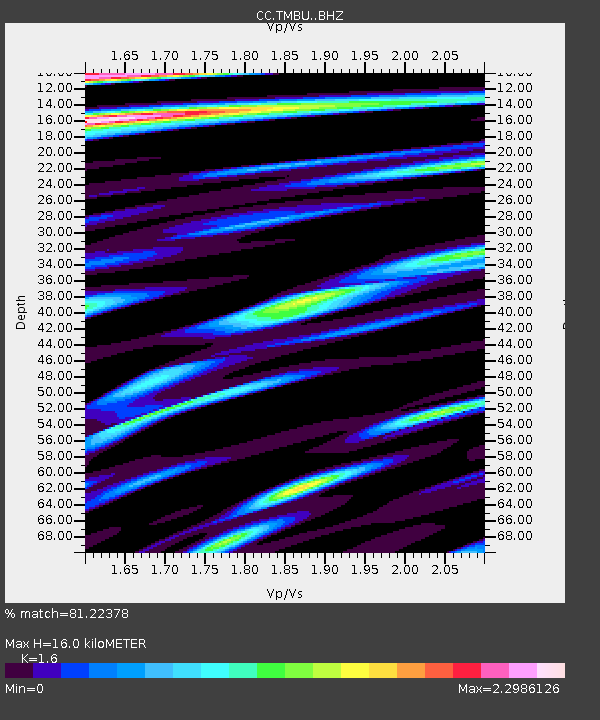
| Estimated Moho Depth: |
16.0 km |
| Estimated Crust Vp/Vs: |
1.60 |
| Assumed Crust Vp: |
6.597 km/s |
| Estimated Crust Vs: |
4.123 km/s |
| Estimated Crust Poisson's Ratio: |
0.18 |
|
| Radial Match: |
81.22378 % |
| Radial Bump: |
400 |
| Transverse Match: |
66.8131 % |
| Transverse Bump: |
400 |
| SOD ConfigId: |
21709731 |
| Insert Time: |
2020-08-30 20:35:43.091 +0000 |
| GWidth: |
2.5 |
| Max Bumps: |
400 |
| Tol: |
0.001 |
|

Signal To Noise
| Channel | StoN | STA | LTA |
| CC:TMBU: :BHZ:20200816T20:12:02.62499Z | 1.383375 | 1.2413386E-7 | 8.9732616E-8 |
| CC:TMBU: :BHN:20200816T20:12:02.62499Z | 1.4231831 | 2.4759356E-7 | 1.739717E-7 |
| CC:TMBU: :BHE:20200816T20:12:02.62499Z | 0.7545276 | 1.9369287E-7 | 2.5670747E-7 |
| Arrivals |
| Ps | 1.6 SECOND |
| PpPs | 5.8 SECOND |
| PsPs/PpSs | 7.3 SECOND |


