You are here: Home > Network List > GS - US Geological Survey Networks Stations List
> Station OK031 S. Brethren Rd., Cushing, OK, USA > Earthquake Result Viewer
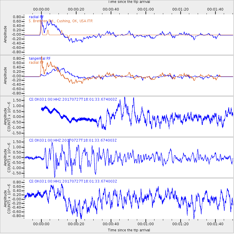
OK031 S. Brethren Rd., Cushing, OK, USA - Earthquake Result Viewer
*The percent match for this event was below the threshold and hence no stack was calculated.
| Earthquake location: |
North Atlantic Ocean |
| Earthquake latitude/longitude: |
13.4/-49.4 |
| Earthquake time(UTC): |
2017/07/27 (208) 17:53:25 GMT |
| Earthquake Depth: |
10 km |
| Earthquake Magnitude: |
5.9 Mww |
| Earthquake Catalog/Contributor: |
NEIC PDE/us |
|
| Network: |
GS US Geological Survey Networks |
| Station: |
OK031 S. Brethren Rd., Cushing, OK, USA |
| Lat/Lon: |
35.95 N/96.84 W |
| Elevation: |
290 m |
|
| Distance: |
48.1 deg |
| Az: |
306.519 deg |
| Baz: |
105.43 deg |
| Ray Param: |
$rayparam |
*The percent match for this event was below the threshold and hence was not used in the summary stack. |
|
| Radial Match: |
56.02728 % |
| Radial Bump: |
400 |
| Transverse Match: |
58.0035 % |
| Transverse Bump: |
400 |
| SOD ConfigId: |
2140511 |
| Insert Time: |
2017-08-10 09:46:47.332 +0000 |
| GWidth: |
2.5 |
| Max Bumps: |
400 |
| Tol: |
0.001 |
|
Signal To Noise
| Channel | StoN | STA | LTA |
| GS:OK031:00:HHZ:20170727T18:01:33.674003Z | 5.797903 | 5.3656646E-7 | 9.2544916E-8 |
| GS:OK031:00:HH1:20170727T18:01:33.674003Z | 1.875176 | 3.469221E-7 | 1.8500775E-7 |
| GS:OK031:00:HH2:20170727T18:01:33.674003Z | 1.4188849 | 6.1399487E-7 | 4.327306E-7 |
| Arrivals |
| Ps | |
| PpPs | |
| PsPs/PpSs | |


