You are here: Home > Network List > TJ - Tajikistan National Seismic Network Stations List
> Station SHAA Shaartuz, Tajikistan > Earthquake Result Viewer
SHAA Shaartuz, Tajikistan - Earthquake Result Viewer
| Earthquake location: |
Fox Islands, Aleutian Islands |
| Earthquake latitude/longitude: |
51.1/-171.1 |
| Earthquake time(UTC): |
2020/08/16 (229) 20:05:48 GMT |
| Earthquake Depth: |
10 km |
| Earthquake Magnitude: |
5.7 Mww |
| Earthquake Catalog/Contributor: |
NEIC PDE/us |
|
| Network: |
TJ Tajikistan National Seismic Network |
| Station: |
SHAA Shaartuz, Tajikistan |
| Lat/Lon: |
37.56 N/68.12 E |
| Elevation: |
868 m |
|
| Distance: |
77.6 deg |
| Az: |
315.63 deg |
| Baz: |
33.699 deg |
| Ray Param: |
0.050232083 |
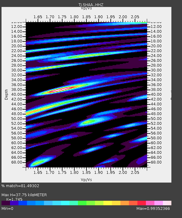
| Estimated Moho Depth: |
37.75 km |
| Estimated Crust Vp/Vs: |
1.75 |
| Assumed Crust Vp: |
6.213 km/s |
| Estimated Crust Vs: |
3.561 km/s |
| Estimated Crust Poisson's Ratio: |
0.26 |
|
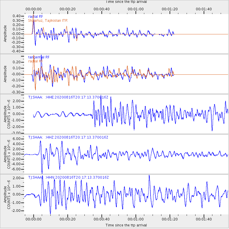
| Radial Match: |
81.49302 % |
| Radial Bump: |
400 |
| Transverse Match: |
79.866035 % |
| Transverse Bump: |
400 |
| SOD ConfigId: |
21709731 |
| Insert Time: |
2020-08-30 20:50:13.129 +0000 |
| GWidth: |
2.5 |
| Max Bumps: |
400 |
| Tol: |
0.001 |
|
Signal To Noise
| Channel | StoN | STA | LTA |
| TJ:SHAA: :HHZ:20200816T20:17:13.370016Z | 10.938862 | 1.9446295E-6 | 1.7777256E-7 |
| TJ:SHAA: :HHN:20200816T20:17:13.370016Z | 2.1396685 | 4.6959045E-7 | 2.1946879E-7 |
| TJ:SHAA: :HHE:20200816T20:17:13.370016Z | 0.75744003 | 1.7422212E-7 | 2.3001442E-7 |
| Arrivals |
| Ps | 4.7 SECOND |
| PpPs | 16 SECOND |
| PsPs/PpSs | 21 SECOND |


