You are here: Home > Network List > YX16 - Raton Basin UNM Broadband Network Stations List
> Station UNM5 Southernmost CO Station > Earthquake Result Viewer
UNM5 Southernmost CO Station - Earthquake Result Viewer
| Earthquake location: |
Fox Islands, Aleutian Islands |
| Earthquake latitude/longitude: |
51.1/-171.1 |
| Earthquake time(UTC): |
2020/08/16 (229) 20:05:48 GMT |
| Earthquake Depth: |
10 km |
| Earthquake Magnitude: |
5.7 Mww |
| Earthquake Catalog/Contributor: |
NEIC PDE/us |
|
| Network: |
YX Raton Basin UNM Broadband Network |
| Station: |
UNM5 Southernmost CO Station |
| Lat/Lon: |
37.12 N/104.78 W |
| Elevation: |
2035 m |
|
| Distance: |
48.0 deg |
| Az: |
79.935 deg |
| Baz: |
309.042 deg |
| Ray Param: |
0.06962817 |
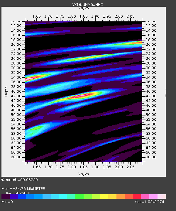
| Estimated Moho Depth: |
34.75 km |
| Estimated Crust Vp/Vs: |
1.60 |
| Assumed Crust Vp: |
6.316 km/s |
| Estimated Crust Vs: |
3.941 km/s |
| Estimated Crust Poisson's Ratio: |
0.18 |
|
| Radial Match: |
89.05239 % |
| Radial Bump: |
400 |
| Transverse Match: |
70.639244 % |
| Transverse Bump: |
400 |
| SOD ConfigId: |
21709731 |
| Insert Time: |
2020-08-30 20:54:14.860 +0000 |
| GWidth: |
2.5 |
| Max Bumps: |
400 |
| Tol: |
0.001 |
|

Signal To Noise
| Channel | StoN | STA | LTA |
| YX:UNM5: :HHZ:20200816T20:13:56.929006Z | 1.4075484 | 7.032975E-8 | 4.9966133E-8 |
| YX:UNM5: :HHN:20200816T20:13:56.929006Z | 1.0782449 | 1.03284165E-7 | 9.5789154E-8 |
| YX:UNM5: :HHE:20200816T20:13:56.929006Z | 1.7688619 | 1.6708131E-7 | 9.445695E-8 |
| Arrivals |
| Ps | 3.5 SECOND |
| PpPs | 13 SECOND |
| PsPs/PpSs | 17 SECOND |


