You are here: Home > Network List > AK - Alaska Regional Network Stations List
> Station JIS Juneau Island, AK, USA > Earthquake Result Viewer
JIS Juneau Island, AK, USA - Earthquake Result Viewer
| Earthquake location: |
Samar, Philippines |
| Earthquake latitude/longitude: |
12.0/124.1 |
| Earthquake time(UTC): |
2020/08/18 (231) 00:03:48 GMT |
| Earthquake Depth: |
10 km |
| Earthquake Magnitude: |
6.7 mww |
| Earthquake Catalog/Contributor: |
NEIC PDE/us |
|
| Network: |
AK Alaska Regional Network |
| Station: |
JIS Juneau Island, AK, USA |
| Lat/Lon: |
58.28 N/134.38 W |
| Elevation: |
10 m |
|
| Distance: |
85.8 deg |
| Az: |
31.273 deg |
| Baz: |
286.005 deg |
| Ray Param: |
0.044473175 |
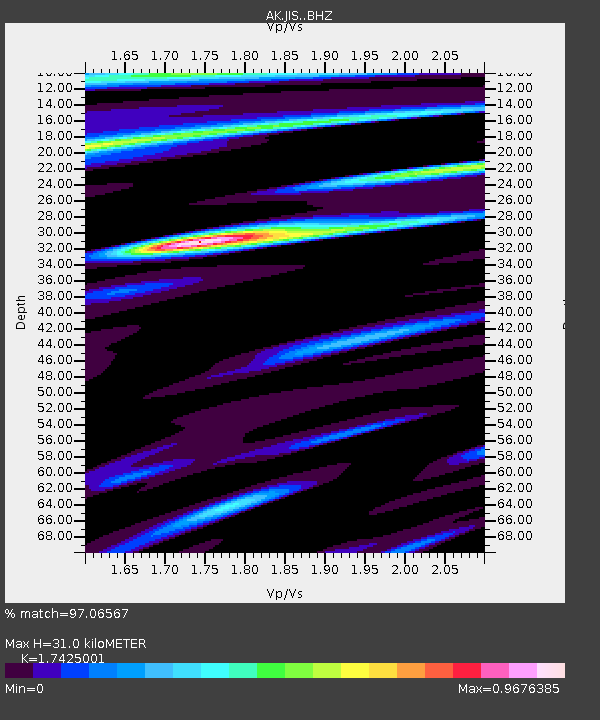
| Estimated Moho Depth: |
31.0 km |
| Estimated Crust Vp/Vs: |
1.74 |
| Assumed Crust Vp: |
6.566 km/s |
| Estimated Crust Vs: |
3.768 km/s |
| Estimated Crust Poisson's Ratio: |
0.25 |
|
| Radial Match: |
97.06567 % |
| Radial Bump: |
330 |
| Transverse Match: |
94.17596 % |
| Transverse Bump: |
400 |
| SOD ConfigId: |
21709731 |
| Insert Time: |
2020-09-01 00:05:45.860 +0000 |
| GWidth: |
2.5 |
| Max Bumps: |
400 |
| Tol: |
0.001 |
|

Signal To Noise
| Channel | StoN | STA | LTA |
| AK:JIS: :BHZ:20200818T00:15:57.107999Z | 4.202856 | 2.1284028E-7 | 5.064182E-8 |
| AK:JIS: :BHN:20200818T00:15:57.107999Z | 1.5111482 | 5.9420156E-8 | 3.9321197E-8 |
| AK:JIS: :BHE:20200818T00:15:57.107999Z | 1.8664366 | 9.991324E-8 | 5.3531547E-8 |
| Arrivals |
| Ps | 3.6 SECOND |
| PpPs | 13 SECOND |
| PsPs/PpSs | 16 SECOND |


