You are here: Home > Network List > AK - Alaska Regional Network Stations List
> Station L18K Granite Mountain, AK, USA > Earthquake Result Viewer
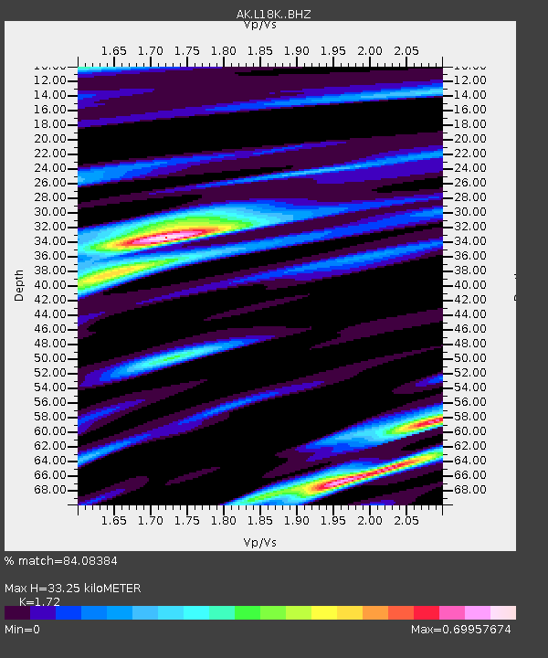
L18K Granite Mountain, AK, USA - Earthquake Result Viewer
| Earthquake location: |
Samar, Philippines |
| Earthquake latitude/longitude: |
12.0/124.1 |
| Earthquake time(UTC): |
2020/08/18 (231) 00:03:48 GMT |
| Earthquake Depth: |
10 km |
| Earthquake Magnitude: |
6.7 mww |
| Earthquake Catalog/Contributor: |
NEIC PDE/us |
|
| Network: |
AK Alaska Regional Network |
| Station: |
L18K Granite Mountain, AK, USA |
| Lat/Lon: |
62.22 N/156.69 W |
| Elevation: |
329 m |
|
| Distance: |
74.4 deg |
| Az: |
28.541 deg |
| Baz: |
266.129 deg |
| Ray Param: |
0.052354705 |
| Estimated Moho Depth: |
33.25 km |
| Estimated Crust Vp/Vs: |
1.72 |
| Assumed Crust Vp: |
6.182 km/s |
| Estimated Crust Vs: |
3.594 km/s |
| Estimated Crust Poisson's Ratio: |
0.24 |
|
| Radial Match: |
84.08384 % |
| Radial Bump: |
323 |
| Transverse Match: |
75.91299 % |
| Transverse Bump: |
324 |
| SOD ConfigId: |
21709731 |
| Insert Time: |
2020-09-01 00:05:57.071 +0000 |
| GWidth: |
2.5 |
| Max Bumps: |
400 |
| Tol: |
0.001 |
|

Signal To Noise
| Channel | StoN | STA | LTA |
| AK:L18K: :BHZ:20200818T00:14:55.719998Z | 6.7809815 | 3.708896E-7 | 5.4695562E-8 |
| AK:L18K: :BHN:20200818T00:14:55.719998Z | 0.6487572 | 4.3091063E-8 | 6.642094E-8 |
| AK:L18K: :BHE:20200818T00:14:55.719998Z | 3.374738 | 1.4196054E-7 | 4.2065647E-8 |
| Arrivals |
| Ps | 4.0 SECOND |
| PpPs | 14 SECOND |
| PsPs/PpSs | 18 SECOND |


