You are here: Home > Network List > NM - Cooperative New Madrid Seismic Network Stations List
> Station HBAR Harrisburg,AR(CERI) > Earthquake Result Viewer
HBAR Harrisburg,AR(CERI) - Earthquake Result Viewer
| Earthquake location: |
North Atlantic Ocean |
| Earthquake latitude/longitude: |
13.4/-49.4 |
| Earthquake time(UTC): |
2017/07/27 (208) 17:53:25 GMT |
| Earthquake Depth: |
10 km |
| Earthquake Magnitude: |
5.9 Mww |
| Earthquake Catalog/Contributor: |
NEIC PDE/us |
|
| Network: |
NM Cooperative New Madrid Seismic Network |
| Station: |
HBAR Harrisburg,AR(CERI) |
| Lat/Lon: |
35.56 N/90.66 W |
| Elevation: |
74 m |
|
| Distance: |
43.2 deg |
| Az: |
308.14 deg |
| Baz: |
110.164 deg |
| Ray Param: |
0.07272812 |
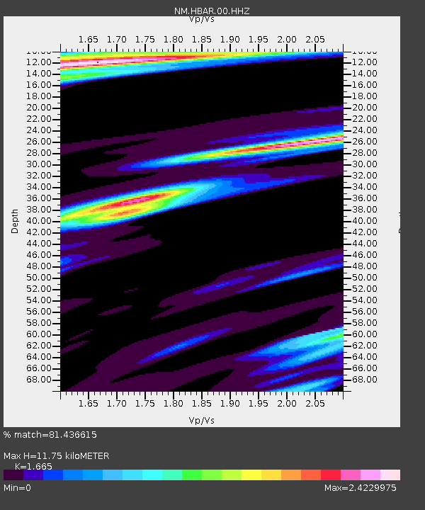
| Estimated Moho Depth: |
11.75 km |
| Estimated Crust Vp/Vs: |
1.66 |
| Assumed Crust Vp: |
6.273 km/s |
| Estimated Crust Vs: |
3.768 km/s |
| Estimated Crust Poisson's Ratio: |
0.22 |
|
| Radial Match: |
81.436615 % |
| Radial Bump: |
336 |
| Transverse Match: |
64.46476 % |
| Transverse Bump: |
400 |
| SOD ConfigId: |
2140511 |
| Insert Time: |
2017-08-10 09:48:17.649 +0000 |
| GWidth: |
2.5 |
| Max Bumps: |
400 |
| Tol: |
0.001 |
|

Signal To Noise
| Channel | StoN | STA | LTA |
| NM:HBAR:00:HHZ:20170727T18:00:54.90499Z | 2.9293845 | 5.5690276E-7 | 1.9010913E-7 |
| NM:HBAR:00:HHN:20170727T18:00:54.90499Z | 1.733811 | 5.090922E-7 | 2.9362613E-7 |
| NM:HBAR:00:HHE:20170727T18:00:54.90499Z | 1.7423949 | 5.136814E-7 | 2.9481342E-7 |
| Arrivals |
| Ps | 1.3 SECOND |
| PpPs | 4.7 SECOND |
| PsPs/PpSs | 6.0 SECOND |


