You are here: Home > Network List > AV - Alaska Volcano Observatory Stations List
> Station AUSS Augustine Summit Station, Augustine Volcano, Alaska > Earthquake Result Viewer
AUSS Augustine Summit Station, Augustine Volcano, Alaska - Earthquake Result Viewer

| Earthquake location: |
Samar, Philippines |
| Earthquake latitude/longitude: |
12.0/124.1 |
| Earthquake time(UTC): |
2020/08/18 (231) 00:03:48 GMT |
| Earthquake Depth: |
10 km |
| Earthquake Magnitude: |
6.7 mww |
| Earthquake Catalog/Contributor: |
NEIC PDE/us |
|
| Network: |
AV Alaska Volcano Observatory |
| Station: |
AUSS Augustine Summit Station, Augustine Volcano, Alaska |
| Lat/Lon: |
59.36 N/153.43 W |
| Elevation: |
1235 m |
|
| Distance: |
75.9 deg |
| Az: |
31.567 deg |
| Baz: |
269.744 deg |
| Ray Param: |
0.051350046 |
| Estimated Moho Depth: |
69.0 km |
| Estimated Crust Vp/Vs: |
1.88 |
| Assumed Crust Vp: |
5.989 km/s |
| Estimated Crust Vs: |
3.194 km/s |
| Estimated Crust Poisson's Ratio: |
0.30 |
|
| Radial Match: |
80.91546 % |
| Radial Bump: |
379 |
| Transverse Match: |
85.98468 % |
| Transverse Bump: |
341 |
| SOD ConfigId: |
21709731 |
| Insert Time: |
2020-09-01 00:08:30.655 +0000 |
| GWidth: |
2.5 |
| Max Bumps: |
400 |
| Tol: |
0.001 |
|
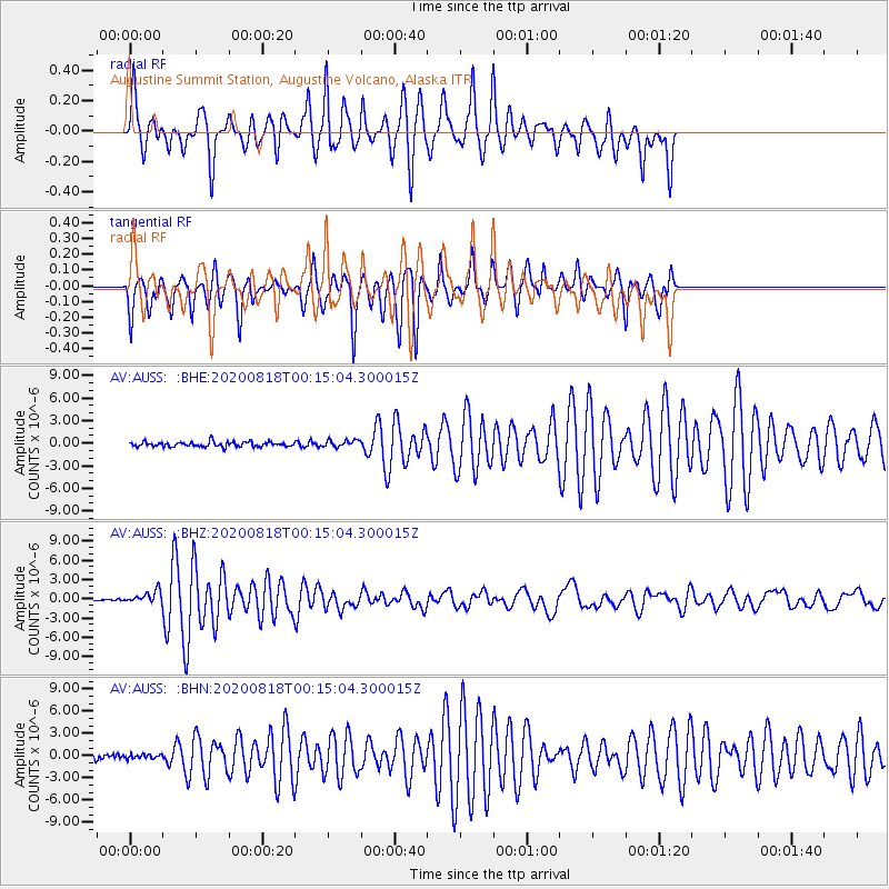
Signal To Noise
| Channel | StoN | STA | LTA |
| AV:AUSS: :BHZ:20200818T00:15:04.300015Z | 7.288747 | 9.784034E-7 | 1.3423478E-7 |
| AV:AUSS: :BHN:20200818T00:15:04.300015Z | 0.79452574 | 2.6715858E-7 | 3.3624912E-7 |
| AV:AUSS: :BHE:20200818T00:15:04.300015Z | 1.4593723 | 4.6032184E-7 | 3.1542456E-7 |
| Arrivals |
| Ps | 10 SECOND |
| PpPs | 32 SECOND |
| PsPs/PpSs | 43 SECOND |


