You are here: Home > Network List > AV - Alaska Volcano Observatory Stations List
> Station DT1 Dutton Round Hill, Mount Dutton, Alaska > Earthquake Result Viewer
DT1 Dutton Round Hill, Mount Dutton, Alaska - Earthquake Result Viewer
| Earthquake location: |
Samar, Philippines |
| Earthquake latitude/longitude: |
12.0/124.1 |
| Earthquake time(UTC): |
2020/08/18 (231) 00:03:48 GMT |
| Earthquake Depth: |
10 km |
| Earthquake Magnitude: |
6.7 mww |
| Earthquake Catalog/Contributor: |
NEIC PDE/us |
|
| Network: |
AV Alaska Volcano Observatory |
| Station: |
DT1 Dutton Round Hill, Mount Dutton, Alaska |
| Lat/Lon: |
55.11 N/162.28 W |
| Elevation: |
198 m |
|
| Distance: |
70.9 deg |
| Az: |
35.7 deg |
| Baz: |
263.491 deg |
| Ray Param: |
0.054709524 |
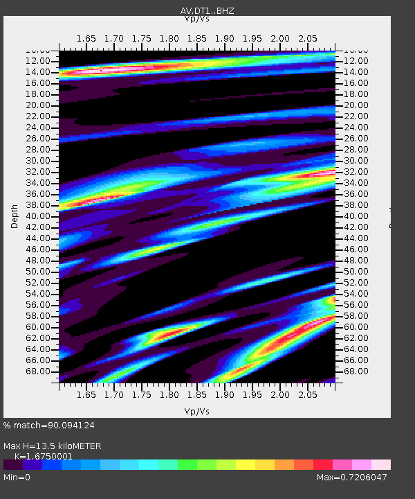
| Estimated Moho Depth: |
13.5 km |
| Estimated Crust Vp/Vs: |
1.68 |
| Assumed Crust Vp: |
5.989 km/s |
| Estimated Crust Vs: |
3.576 km/s |
| Estimated Crust Poisson's Ratio: |
0.22 |
|
| Radial Match: |
90.094124 % |
| Radial Bump: |
331 |
| Transverse Match: |
82.90527 % |
| Transverse Bump: |
400 |
| SOD ConfigId: |
21709731 |
| Insert Time: |
2020-09-01 00:08:35.911 +0000 |
| GWidth: |
2.5 |
| Max Bumps: |
400 |
| Tol: |
0.001 |
|

Signal To Noise
| Channel | StoN | STA | LTA |
| AV:DT1: :BHZ:20200818T00:14:34.600003Z | 7.5660863 | 6.523366E-7 | 8.6218506E-8 |
| AV:DT1: :BHN:20200818T00:14:34.600003Z | 1.3993704 | 1.2547135E-7 | 8.9662706E-8 |
| AV:DT1: :BHE:20200818T00:14:34.600003Z | 4.195003 | 3.4980215E-7 | 8.338544E-8 |
| Arrivals |
| Ps | 1.6 SECOND |
| PpPs | 5.8 SECOND |
| PsPs/PpSs | 7.4 SECOND |


