You are here: Home > Network List > AV - Alaska Volcano Observatory Stations List
> Station KABU KABU - Katmai Volcanic Cluster, Alaska > Earthquake Result Viewer
KABU KABU - Katmai Volcanic Cluster, Alaska - Earthquake Result Viewer

| Earthquake location: |
Samar, Philippines |
| Earthquake latitude/longitude: |
12.0/124.1 |
| Earthquake time(UTC): |
2020/08/18 (231) 00:03:48 GMT |
| Earthquake Depth: |
10 km |
| Earthquake Magnitude: |
6.7 mww |
| Earthquake Catalog/Contributor: |
NEIC PDE/us |
|
| Network: |
AV Alaska Volcano Observatory |
| Station: |
KABU KABU - Katmai Volcanic Cluster, Alaska |
| Lat/Lon: |
58.27 N/155.28 W |
| Elevation: |
1065 m |
|
| Distance: |
74.9 deg |
| Az: |
32.679 deg |
| Baz: |
268.443 deg |
| Ray Param: |
0.05199814 |
| Estimated Moho Depth: |
27.0 km |
| Estimated Crust Vp/Vs: |
2.02 |
| Assumed Crust Vp: |
6.438 km/s |
| Estimated Crust Vs: |
3.183 km/s |
| Estimated Crust Poisson's Ratio: |
0.34 |
|
| Radial Match: |
86.07408 % |
| Radial Bump: |
400 |
| Transverse Match: |
87.82037 % |
| Transverse Bump: |
378 |
| SOD ConfigId: |
21709731 |
| Insert Time: |
2020-09-01 00:08:56.542 +0000 |
| GWidth: |
2.5 |
| Max Bumps: |
400 |
| Tol: |
0.001 |
|
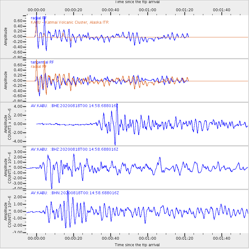
Signal To Noise
| Channel | StoN | STA | LTA |
| AV:KABU: :BHZ:20200818T00:14:58.688016Z | 10.928338 | 5.0123157E-7 | 4.5865306E-8 |
| AV:KABU: :BHN:20200818T00:14:58.688016Z | 1.0706279 | 1.01635E-7 | 9.493028E-8 |
| AV:KABU: :BHE:20200818T00:14:58.688016Z | 3.3956008 | 3.4148906E-7 | 1.0056808E-7 |
| Arrivals |
| Ps | 4.4 SECOND |
| PpPs | 12 SECOND |
| PsPs/PpSs | 17 SECOND |


