You are here: Home > Network List > AV - Alaska Volcano Observatory Stations List
> Station KIRH Round Head, Kanaga Volcano, Alaska > Earthquake Result Viewer
KIRH Round Head, Kanaga Volcano, Alaska - Earthquake Result Viewer
| Earthquake location: |
Samar, Philippines |
| Earthquake latitude/longitude: |
12.0/124.1 |
| Earthquake time(UTC): |
2020/08/18 (231) 00:03:48 GMT |
| Earthquake Depth: |
10 km |
| Earthquake Magnitude: |
6.7 mww |
| Earthquake Catalog/Contributor: |
NEIC PDE/us |
|
| Network: |
AV Alaska Volcano Observatory |
| Station: |
KIRH Round Head, Kanaga Volcano, Alaska |
| Lat/Lon: |
51.90 N/177.09 W |
| Elevation: |
321 m |
|
| Distance: |
61.6 deg |
| Az: |
37.067 deg |
| Baz: |
252.136 deg |
| Ray Param: |
0.060795415 |
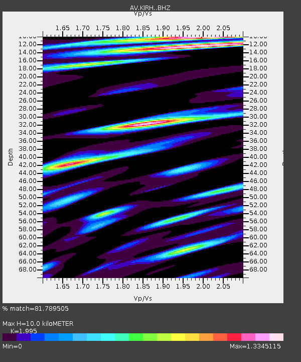
| Estimated Moho Depth: |
10.0 km |
| Estimated Crust Vp/Vs: |
2.00 |
| Assumed Crust Vp: |
5.88 km/s |
| Estimated Crust Vs: |
2.948 km/s |
| Estimated Crust Poisson's Ratio: |
0.33 |
|
| Radial Match: |
81.789505 % |
| Radial Bump: |
400 |
| Transverse Match: |
80.80071 % |
| Transverse Bump: |
400 |
| SOD ConfigId: |
21709731 |
| Insert Time: |
2020-09-01 00:09:05.845 +0000 |
| GWidth: |
2.5 |
| Max Bumps: |
400 |
| Tol: |
0.001 |
|

Signal To Noise
| Channel | StoN | STA | LTA |
| AV:KIRH: :BHZ:20200818T00:13:35.019986Z | 2.619153 | 7.906908E-7 | 3.0188798E-7 |
| AV:KIRH: :BHN:20200818T00:13:35.019986Z | 1.1627505 | 5.627195E-7 | 4.839555E-7 |
| AV:KIRH: :BHE:20200818T00:13:35.019986Z | 1.2210677 | 5.0075425E-7 | 4.100954E-7 |
| Arrivals |
| Ps | 1.7 SECOND |
| PpPs | 4.9 SECOND |
| PsPs/PpSs | 6.7 SECOND |


