You are here: Home > Network List > AV - Alaska Volcano Observatory Stations List
> Station MCIR Makushin Cirque, Makushin Volcano, Alaska > Earthquake Result Viewer
MCIR Makushin Cirque, Makushin Volcano, Alaska - Earthquake Result Viewer
| Earthquake location: |
Samar, Philippines |
| Earthquake latitude/longitude: |
12.0/124.1 |
| Earthquake time(UTC): |
2020/08/18 (231) 00:03:48 GMT |
| Earthquake Depth: |
10 km |
| Earthquake Magnitude: |
6.7 mww |
| Earthquake Catalog/Contributor: |
NEIC PDE/us |
|
| Network: |
AV Alaska Volcano Observatory |
| Station: |
MCIR Makushin Cirque, Makushin Volcano, Alaska |
| Lat/Lon: |
53.95 N/166.89 W |
| Elevation: |
800 m |
|
| Distance: |
68.0 deg |
| Az: |
36.512 deg |
| Baz: |
260.026 deg |
| Ray Param: |
0.05656932 |
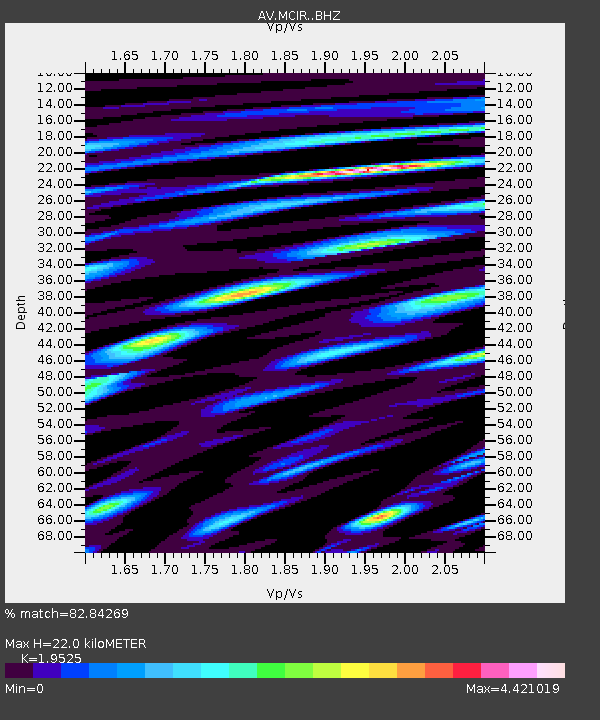
| Estimated Moho Depth: |
22.0 km |
| Estimated Crust Vp/Vs: |
1.95 |
| Assumed Crust Vp: |
3.943 km/s |
| Estimated Crust Vs: |
2.02 km/s |
| Estimated Crust Poisson's Ratio: |
0.32 |
|
| Radial Match: |
82.84269 % |
| Radial Bump: |
400 |
| Transverse Match: |
66.79221 % |
| Transverse Bump: |
329 |
| SOD ConfigId: |
21709731 |
| Insert Time: |
2020-09-01 00:09:20.015 +0000 |
| GWidth: |
2.5 |
| Max Bumps: |
400 |
| Tol: |
0.001 |
|

Signal To Noise
| Channel | StoN | STA | LTA |
| AV:MCIR: :BHZ:20200818T00:14:17.160Z | 3.3002787 | 7.054961E-7 | 2.1376866E-7 |
| AV:MCIR: :BHN:20200818T00:14:17.160Z | 0.45348144 | 2.4671363E-7 | 5.4404353E-7 |
| AV:MCIR: :BHE:20200818T00:14:17.160Z | 0.8219946 | 5.773879E-7 | 7.02423E-7 |
| Arrivals |
| Ps | 5.4 SECOND |
| PpPs | 16 SECOND |
| PsPs/PpSs | 22 SECOND |


