You are here: Home > Network List > AV - Alaska Volcano Observatory Stations List
> Station MNAT Nateekin Bay, Makushin Volcano, Alaska > Earthquake Result Viewer
MNAT Nateekin Bay, Makushin Volcano, Alaska - Earthquake Result Viewer
| Earthquake location: |
Samar, Philippines |
| Earthquake latitude/longitude: |
12.0/124.1 |
| Earthquake time(UTC): |
2020/08/18 (231) 00:03:48 GMT |
| Earthquake Depth: |
10 km |
| Earthquake Magnitude: |
6.7 mww |
| Earthquake Catalog/Contributor: |
NEIC PDE/us |
|
| Network: |
AV Alaska Volcano Observatory |
| Station: |
MNAT Nateekin Bay, Makushin Volcano, Alaska |
| Lat/Lon: |
53.88 N/166.69 W |
| Elevation: |
390 m |
|
| Distance: |
68.1 deg |
| Az: |
36.607 deg |
| Baz: |
260.23 deg |
| Ray Param: |
0.056496788 |
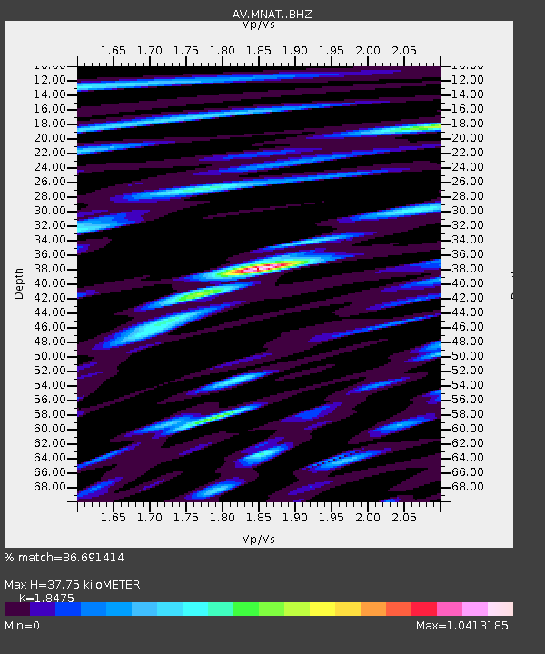
| Estimated Moho Depth: |
37.75 km |
| Estimated Crust Vp/Vs: |
1.85 |
| Assumed Crust Vp: |
3.943 km/s |
| Estimated Crust Vs: |
2.134 km/s |
| Estimated Crust Poisson's Ratio: |
0.29 |
|
| Radial Match: |
86.691414 % |
| Radial Bump: |
400 |
| Transverse Match: |
93.2473 % |
| Transverse Bump: |
400 |
| SOD ConfigId: |
21709731 |
| Insert Time: |
2020-09-01 00:09:23.065 +0000 |
| GWidth: |
2.5 |
| Max Bumps: |
400 |
| Tol: |
0.001 |
|
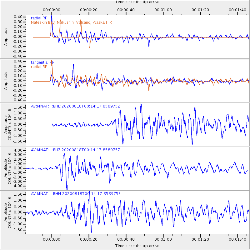
Signal To Noise
| Channel | StoN | STA | LTA |
| AV:MNAT: :BHZ:20200818T00:14:17.858975Z | 5.0491796 | 4.7758505E-7 | 9.458667E-8 |
| AV:MNAT: :BHN:20200818T00:14:17.858975Z | 1.2322489 | 1.12895925E-7 | 9.161779E-8 |
| AV:MNAT: :BHE:20200818T00:14:17.858975Z | 2.5454571 | 2.3567205E-7 | 9.258535E-8 |
| Arrivals |
| Ps | 8.2 SECOND |
| PpPs | 27 SECOND |
| PsPs/PpSs | 35 SECOND |


