You are here: Home > Network List > AV - Alaska Volcano Observatory Stations List
> Station RDT Redoubt, Alaska > Earthquake Result Viewer
RDT Redoubt, Alaska - Earthquake Result Viewer
| Earthquake location: |
Samar, Philippines |
| Earthquake latitude/longitude: |
12.0/124.1 |
| Earthquake time(UTC): |
2020/08/18 (231) 00:03:48 GMT |
| Earthquake Depth: |
10 km |
| Earthquake Magnitude: |
6.7 mww |
| Earthquake Catalog/Contributor: |
NEIC PDE/us |
|
| Network: |
AV Alaska Volcano Observatory |
| Station: |
RDT Redoubt, Alaska |
| Lat/Lon: |
60.57 N/152.41 W |
| Elevation: |
930 m |
|
| Distance: |
76.4 deg |
| Az: |
30.313 deg |
| Baz: |
270.329 deg |
| Ray Param: |
0.051006675 |
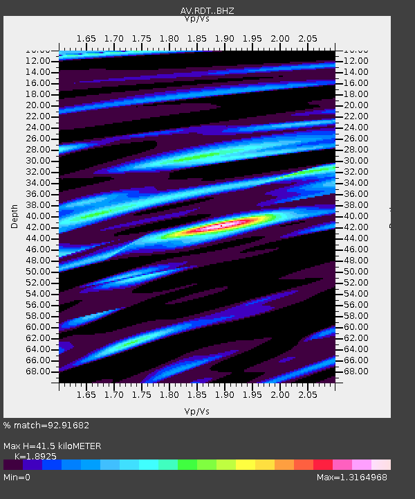
| Estimated Moho Depth: |
41.5 km |
| Estimated Crust Vp/Vs: |
1.89 |
| Assumed Crust Vp: |
6.566 km/s |
| Estimated Crust Vs: |
3.47 km/s |
| Estimated Crust Poisson's Ratio: |
0.31 |
|
| Radial Match: |
92.91682 % |
| Radial Bump: |
400 |
| Transverse Match: |
88.65441 % |
| Transverse Bump: |
400 |
| SOD ConfigId: |
21709731 |
| Insert Time: |
2020-09-01 00:09:40.814 +0000 |
| GWidth: |
2.5 |
| Max Bumps: |
400 |
| Tol: |
0.001 |
|

Signal To Noise
| Channel | StoN | STA | LTA |
| AV:RDT: :BHZ:20200818T00:15:07.219021Z | 8.827244 | 3.60744E-7 | 4.0867114E-8 |
| AV:RDT: :BHN:20200818T00:15:07.219021Z | 1.5009738 | 8.345758E-8 | 5.560229E-8 |
| AV:RDT: :BHE:20200818T00:15:07.219021Z | 2.1175065 | 1.530755E-7 | 7.2290455E-8 |
| Arrivals |
| Ps | 5.8 SECOND |
| PpPs | 18 SECOND |
| PsPs/PpSs | 24 SECOND |


