You are here: Home > Network List > G - GEOSCOPE Stations List
> Station DRV Dumont d'Urville, Terre Adelie (Antartica) > Earthquake Result Viewer
DRV Dumont d'Urville, Terre Adelie (Antartica) - Earthquake Result Viewer
| Earthquake location: |
Samar, Philippines |
| Earthquake latitude/longitude: |
12.0/124.1 |
| Earthquake time(UTC): |
2020/08/18 (231) 00:03:48 GMT |
| Earthquake Depth: |
10 km |
| Earthquake Magnitude: |
6.7 mww |
| Earthquake Catalog/Contributor: |
NEIC PDE/us |
|
| Network: |
G GEOSCOPE |
| Station: |
DRV Dumont d'Urville, Terre Adelie (Antartica) |
| Lat/Lon: |
66.67 S/140.01 E |
| Elevation: |
40 m |
|
| Distance: |
79.3 deg |
| Az: |
173.623 deg |
| Baz: |
344.168 deg |
| Ray Param: |
0.04904241 |
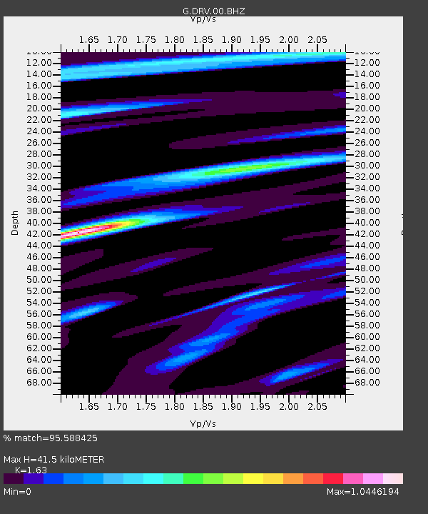
| Estimated Moho Depth: |
41.5 km |
| Estimated Crust Vp/Vs: |
1.63 |
| Assumed Crust Vp: |
6.39 km/s |
| Estimated Crust Vs: |
3.92 km/s |
| Estimated Crust Poisson's Ratio: |
0.20 |
|
| Radial Match: |
95.588425 % |
| Radial Bump: |
400 |
| Transverse Match: |
92.86719 % |
| Transverse Bump: |
400 |
| SOD ConfigId: |
21709731 |
| Insert Time: |
2020-09-01 00:11:43.184 +0000 |
| GWidth: |
2.5 |
| Max Bumps: |
400 |
| Tol: |
0.001 |
|
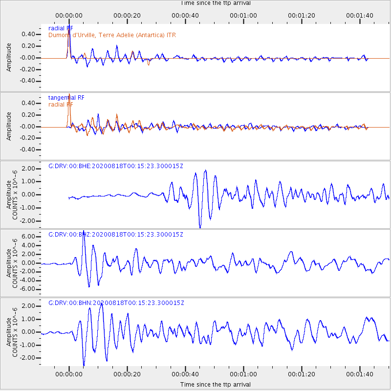
Signal To Noise
| Channel | StoN | STA | LTA |
| G:DRV:00:BHZ:20200818T00:15:23.300015Z | 16.64099 | 1.7789052E-6 | 1.0689901E-7 |
| G:DRV:00:BHN:20200818T00:15:23.300015Z | 4.6382256 | 5.702802E-7 | 1.2295223E-7 |
| G:DRV:00:BHE:20200818T00:15:23.300015Z | 2.3596532 | 2.3672331E-7 | 1.0032123E-7 |
| Arrivals |
| Ps | 4.2 SECOND |
| PpPs | 17 SECOND |
| PsPs/PpSs | 21 SECOND |


