You are here: Home > Network List > IU - Global Seismograph Network (GSN - IRIS/USGS) Stations List
> Station KONO Kongsberg, Norway > Earthquake Result Viewer
KONO Kongsberg, Norway - Earthquake Result Viewer
| Earthquake location: |
Samar, Philippines |
| Earthquake latitude/longitude: |
12.0/124.1 |
| Earthquake time(UTC): |
2020/08/18 (231) 00:03:48 GMT |
| Earthquake Depth: |
10 km |
| Earthquake Magnitude: |
6.7 mww |
| Earthquake Catalog/Contributor: |
NEIC PDE/us |
|
| Network: |
IU Global Seismograph Network (GSN - IRIS/USGS) |
| Station: |
KONO Kongsberg, Norway |
| Lat/Lon: |
59.65 N/9.60 E |
| Elevation: |
216 m |
|
| Distance: |
91.6 deg |
| Az: |
332.468 deg |
| Baz: |
62.947 deg |
| Ray Param: |
0.041585952 |
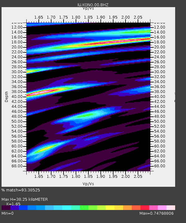
| Estimated Moho Depth: |
38.25 km |
| Estimated Crust Vp/Vs: |
1.65 |
| Assumed Crust Vp: |
6.545 km/s |
| Estimated Crust Vs: |
3.967 km/s |
| Estimated Crust Poisson's Ratio: |
0.21 |
|
| Radial Match: |
93.38525 % |
| Radial Bump: |
258 |
| Transverse Match: |
85.11772 % |
| Transverse Bump: |
316 |
| SOD ConfigId: |
21709731 |
| Insert Time: |
2020-09-01 00:13:05.262 +0000 |
| GWidth: |
2.5 |
| Max Bumps: |
400 |
| Tol: |
0.001 |
|

Signal To Noise
| Channel | StoN | STA | LTA |
| IU:KONO:00:BHZ:20200818T00:16:24.368985Z | 2.6918051 | 5.5973004E-7 | 2.0793854E-7 |
| IU:KONO:00:BH1:20200818T00:16:24.368985Z | 1.2578146 | 1.7476344E-7 | 1.3894213E-7 |
| IU:KONO:00:BH2:20200818T00:16:24.368985Z | 1.0280218 | 1.0863127E-7 | 1.05670196E-7 |
| Arrivals |
| Ps | 3.9 SECOND |
| PpPs | 15 SECOND |
| PsPs/PpSs | 19 SECOND |


