You are here: Home > Network List > IU - Global Seismograph Network (GSN - IRIS/USGS) Stations List
> Station PMG Port Moresby, New Guinea > Earthquake Result Viewer
PMG Port Moresby, New Guinea - Earthquake Result Viewer
| Earthquake location: |
Samar, Philippines |
| Earthquake latitude/longitude: |
12.0/124.1 |
| Earthquake time(UTC): |
2020/08/18 (231) 00:03:48 GMT |
| Earthquake Depth: |
10 km |
| Earthquake Magnitude: |
6.7 mww |
| Earthquake Catalog/Contributor: |
NEIC PDE/us |
|
| Network: |
IU Global Seismograph Network (GSN - IRIS/USGS) |
| Station: |
PMG Port Moresby, New Guinea |
| Lat/Lon: |
9.40 S/147.16 E |
| Elevation: |
90 m |
|
| Distance: |
31.3 deg |
| Az: |
131.889 deg |
| Baz: |
312.426 deg |
| Ray Param: |
0.07913996 |
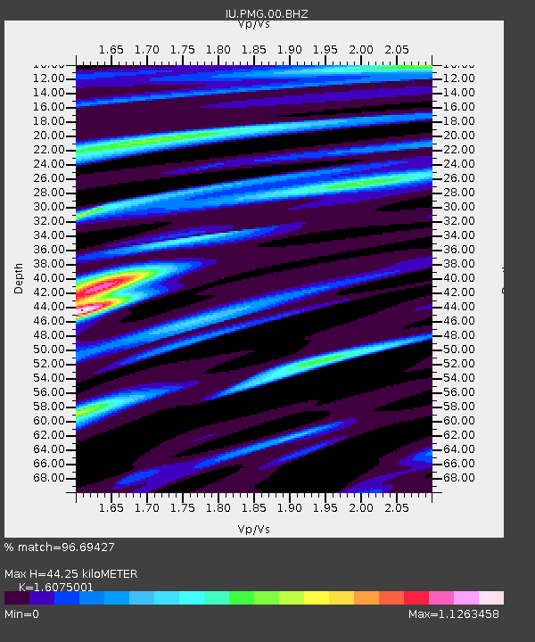
| Estimated Moho Depth: |
44.25 km |
| Estimated Crust Vp/Vs: |
1.61 |
| Assumed Crust Vp: |
6.122 km/s |
| Estimated Crust Vs: |
3.808 km/s |
| Estimated Crust Poisson's Ratio: |
0.18 |
|
| Radial Match: |
96.69427 % |
| Radial Bump: |
252 |
| Transverse Match: |
91.8145 % |
| Transverse Bump: |
399 |
| SOD ConfigId: |
21709731 |
| Insert Time: |
2020-09-01 00:13:10.346 +0000 |
| GWidth: |
2.5 |
| Max Bumps: |
400 |
| Tol: |
0.001 |
|
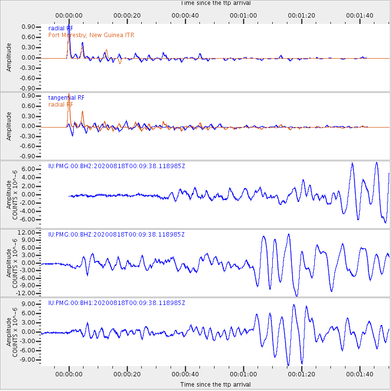
Signal To Noise
| Channel | StoN | STA | LTA |
| IU:PMG:00:BHZ:20200818T00:09:38.118985Z | 7.804927 | 1.0939898E-6 | 1.4016656E-7 |
| IU:PMG:00:BH1:20200818T00:09:38.118985Z | 4.666655 | 5.85861E-7 | 1.2554196E-7 |
| IU:PMG:00:BH2:20200818T00:09:38.118985Z | 3.0105405 | 4.5914766E-7 | 1.5251337E-7 |
| Arrivals |
| Ps | 4.8 SECOND |
| PpPs | 17 SECOND |
| PsPs/PpSs | 22 SECOND |


