You are here: Home > Network List > TA - USArray Transportable Network (new EarthScope stations) Stations List
> Station A36M Sachs Harbour, NT, CAN > Earthquake Result Viewer
A36M Sachs Harbour, NT, CAN - Earthquake Result Viewer
| Earthquake location: |
Samar, Philippines |
| Earthquake latitude/longitude: |
12.0/124.1 |
| Earthquake time(UTC): |
2020/08/18 (231) 00:03:48 GMT |
| Earthquake Depth: |
10 km |
| Earthquake Magnitude: |
6.7 mww |
| Earthquake Catalog/Contributor: |
NEIC PDE/us |
|
| Network: |
TA USArray Transportable Network (new EarthScope stations) |
| Station: |
A36M Sachs Harbour, NT, CAN |
| Lat/Lon: |
71.99 N/125.25 W |
| Elevation: |
32 m |
|
| Distance: |
84.9 deg |
| Az: |
16.996 deg |
| Baz: |
293.188 deg |
| Ray Param: |
0.045167714 |
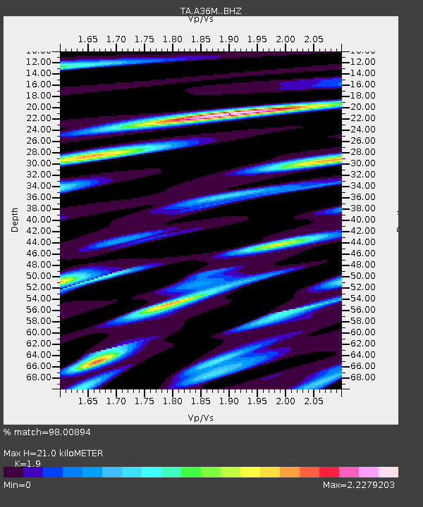
| Estimated Moho Depth: |
21.0 km |
| Estimated Crust Vp/Vs: |
1.90 |
| Assumed Crust Vp: |
6.24 km/s |
| Estimated Crust Vs: |
3.284 km/s |
| Estimated Crust Poisson's Ratio: |
0.31 |
|
| Radial Match: |
98.00894 % |
| Radial Bump: |
359 |
| Transverse Match: |
96.48077 % |
| Transverse Bump: |
312 |
| SOD ConfigId: |
21709731 |
| Insert Time: |
2020-09-01 00:15:21.415 +0000 |
| GWidth: |
2.5 |
| Max Bumps: |
400 |
| Tol: |
0.001 |
|
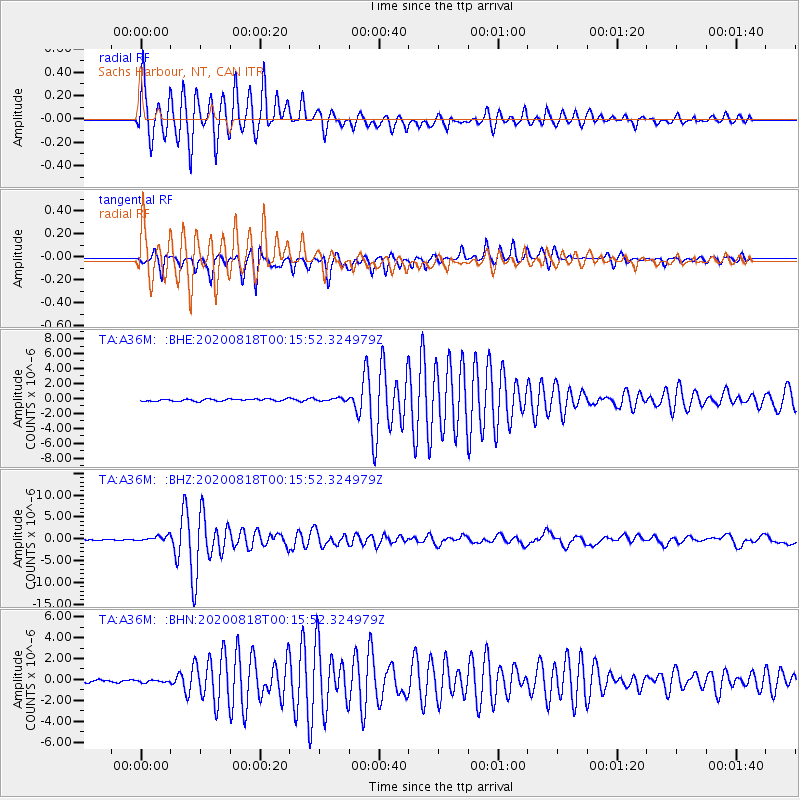
Signal To Noise
| Channel | StoN | STA | LTA |
| TA:A36M: :BHZ:20200818T00:15:52.324979Z | 5.3195896 | 6.492233E-7 | 1.2204386E-7 |
| TA:A36M: :BHN:20200818T00:15:52.324979Z | 0.90086913 | 1.17893684E-7 | 1.3086661E-7 |
| TA:A36M: :BHE:20200818T00:15:52.324979Z | 1.3926849 | 1.9467204E-7 | 1.3978183E-7 |
| Arrivals |
| Ps | 3.1 SECOND |
| PpPs | 9.6 SECOND |
| PsPs/PpSs | 13 SECOND |


