You are here: Home > Network List > TA - USArray Transportable Network (new EarthScope stations) Stations List
> Station C23K Itkillik River, AK, USA > Earthquake Result Viewer
C23K Itkillik River, AK, USA - Earthquake Result Viewer
| Earthquake location: |
Samar, Philippines |
| Earthquake latitude/longitude: |
12.0/124.1 |
| Earthquake time(UTC): |
2020/08/18 (231) 00:03:48 GMT |
| Earthquake Depth: |
10 km |
| Earthquake Magnitude: |
6.7 mww |
| Earthquake Catalog/Contributor: |
NEIC PDE/us |
|
| Network: |
TA USArray Transportable Network (new EarthScope stations) |
| Station: |
C23K Itkillik River, AK, USA |
| Lat/Lon: |
69.84 N/150.61 W |
| Elevation: |
179 m |
|
| Distance: |
77.2 deg |
| Az: |
20.757 deg |
| Baz: |
269.776 deg |
| Ray Param: |
0.050495278 |
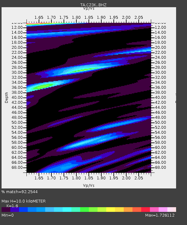
| Estimated Moho Depth: |
10.0 km |
| Estimated Crust Vp/Vs: |
1.60 |
| Assumed Crust Vp: |
6.221 km/s |
| Estimated Crust Vs: |
3.888 km/s |
| Estimated Crust Poisson's Ratio: |
0.18 |
|
| Radial Match: |
92.2544 % |
| Radial Bump: |
346 |
| Transverse Match: |
85.11048 % |
| Transverse Bump: |
366 |
| SOD ConfigId: |
21709731 |
| Insert Time: |
2020-09-01 00:15:32.147 +0000 |
| GWidth: |
2.5 |
| Max Bumps: |
400 |
| Tol: |
0.001 |
|

Signal To Noise
| Channel | StoN | STA | LTA |
| TA:C23K: :BHZ:20200818T00:15:11.449979Z | 5.8168845 | 6.522251E-7 | 1.1212618E-7 |
| TA:C23K: :BHN:20200818T00:15:11.449979Z | 1.0515461 | 1.5202917E-7 | 1.445768E-7 |
| TA:C23K: :BHE:20200818T00:15:11.449979Z | 1.429521 | 2.4679045E-7 | 1.7263856E-7 |
| Arrivals |
| Ps | 1.0 SECOND |
| PpPs | 4.0 SECOND |
| PsPs/PpSs | 5.0 SECOND |


