You are here: Home > Network List > TA - USArray Transportable Network (new EarthScope stations) Stations List
> Station C27K Jago River, AK, USA > Earthquake Result Viewer
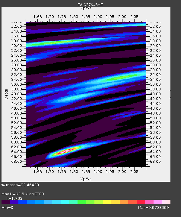
C27K Jago River, AK, USA - Earthquake Result Viewer
| Earthquake location: |
Samar, Philippines |
| Earthquake latitude/longitude: |
12.0/124.1 |
| Earthquake time(UTC): |
2020/08/18 (231) 00:03:48 GMT |
| Earthquake Depth: |
10 km |
| Earthquake Magnitude: |
6.7 mww |
| Earthquake Catalog/Contributor: |
NEIC PDE/us |
|
| Network: |
TA USArray Transportable Network (new EarthScope stations) |
| Station: |
C27K Jago River, AK, USA |
| Lat/Lon: |
69.63 N/143.71 W |
| Elevation: |
392 m |
|
| Distance: |
79.6 deg |
| Az: |
20.843 deg |
| Baz: |
276.263 deg |
| Ray Param: |
0.048857115 |
| Estimated Moho Depth: |
63.5 km |
| Estimated Crust Vp/Vs: |
1.76 |
| Assumed Crust Vp: |
6.522 km/s |
| Estimated Crust Vs: |
3.695 km/s |
| Estimated Crust Poisson's Ratio: |
0.26 |
|
| Radial Match: |
93.46429 % |
| Radial Bump: |
346 |
| Transverse Match: |
93.31691 % |
| Transverse Bump: |
400 |
| SOD ConfigId: |
21709731 |
| Insert Time: |
2020-09-01 00:15:35.604 +0000 |
| GWidth: |
2.5 |
| Max Bumps: |
400 |
| Tol: |
0.001 |
|

Signal To Noise
| Channel | StoN | STA | LTA |
| TA:C27K: :BHZ:20200818T00:15:24.725003Z | 8.648343 | 4.824855E-7 | 5.5789364E-8 |
| TA:C27K: :BHN:20200818T00:15:24.725003Z | 0.63496965 | 3.772152E-8 | 5.940681E-8 |
| TA:C27K: :BHE:20200818T00:15:24.725003Z | 2.3671718 | 1.7665366E-7 | 7.462646E-8 |
| Arrivals |
| Ps | 7.7 SECOND |
| PpPs | 26 SECOND |
| PsPs/PpSs | 34 SECOND |


