You are here: Home > Network List > TA - USArray Transportable Network (new EarthScope stations) Stations List
> Station E27K Coleen River, AK, USA > Earthquake Result Viewer
E27K Coleen River, AK, USA - Earthquake Result Viewer
| Earthquake location: |
Samar, Philippines |
| Earthquake latitude/longitude: |
12.0/124.1 |
| Earthquake time(UTC): |
2020/08/18 (231) 00:03:48 GMT |
| Earthquake Depth: |
10 km |
| Earthquake Magnitude: |
6.7 mww |
| Earthquake Catalog/Contributor: |
NEIC PDE/us |
|
| Network: |
TA USArray Transportable Network (new EarthScope stations) |
| Station: |
E27K Coleen River, AK, USA |
| Lat/Lon: |
68.19 N/141.60 W |
| Elevation: |
654 m |
|
| Distance: |
80.5 deg |
| Az: |
22.2 deg |
| Baz: |
278.47 deg |
| Ray Param: |
0.048207078 |
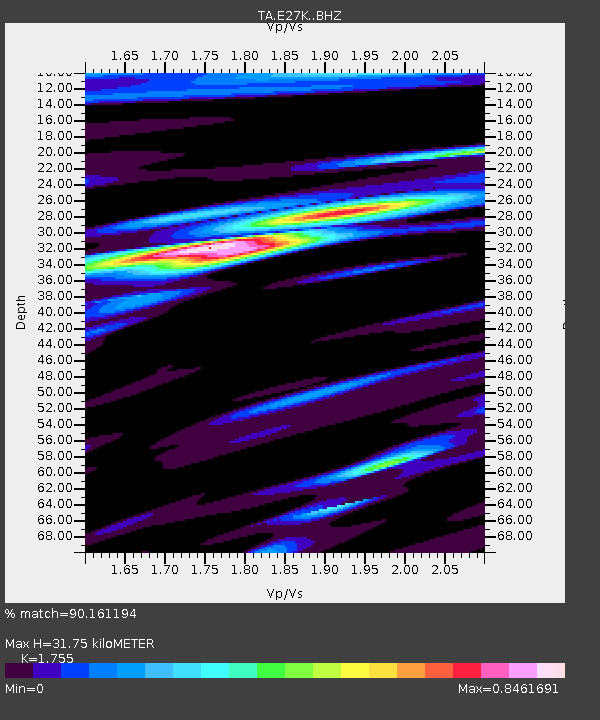
| Estimated Moho Depth: |
31.75 km |
| Estimated Crust Vp/Vs: |
1.75 |
| Assumed Crust Vp: |
6.522 km/s |
| Estimated Crust Vs: |
3.716 km/s |
| Estimated Crust Poisson's Ratio: |
0.26 |
|
| Radial Match: |
90.161194 % |
| Radial Bump: |
389 |
| Transverse Match: |
92.885796 % |
| Transverse Bump: |
399 |
| SOD ConfigId: |
21709731 |
| Insert Time: |
2020-09-01 00:16:02.687 +0000 |
| GWidth: |
2.5 |
| Max Bumps: |
400 |
| Tol: |
0.001 |
|

Signal To Noise
| Channel | StoN | STA | LTA |
| TA:E27K: :BHZ:20200818T00:15:29.824979Z | 6.1130476 | 3.8965922E-7 | 6.374222E-8 |
| TA:E27K: :BHN:20200818T00:15:29.824979Z | 1.9576398 | 1.2458902E-7 | 6.364246E-8 |
| TA:E27K: :BHE:20200818T00:15:29.824979Z | 3.338217 | 1.5693546E-7 | 4.701176E-8 |
| Arrivals |
| Ps | 3.8 SECOND |
| PpPs | 13 SECOND |
| PsPs/PpSs | 17 SECOND |


