You are here: Home > Network List > TA - USArray Transportable Network (new EarthScope stations) Stations List
> Station F21K Alatna River, AK, USA > Earthquake Result Viewer
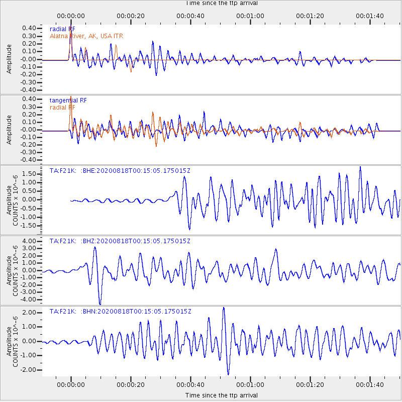
F21K Alatna River, AK, USA - Earthquake Result Viewer
*The percent match for this event was below the threshold and hence no stack was calculated.
| Earthquake location: |
Samar, Philippines |
| Earthquake latitude/longitude: |
12.0/124.1 |
| Earthquake time(UTC): |
2020/08/18 (231) 00:03:48 GMT |
| Earthquake Depth: |
10 km |
| Earthquake Magnitude: |
6.7 mww |
| Earthquake Catalog/Contributor: |
NEIC PDE/us |
|
| Network: |
TA USArray Transportable Network (new EarthScope stations) |
| Station: |
F21K Alatna River, AK, USA |
| Lat/Lon: |
67.22 N/153.48 W |
| Elevation: |
597 m |
|
| Distance: |
76.1 deg |
| Az: |
23.432 deg |
| Baz: |
267.725 deg |
| Ray Param: |
$rayparam |
*The percent match for this event was below the threshold and hence was not used in the summary stack. |
|
| Radial Match: |
79.66094 % |
| Radial Bump: |
400 |
| Transverse Match: |
74.13355 % |
| Transverse Bump: |
400 |
| SOD ConfigId: |
21709731 |
| Insert Time: |
2020-09-01 00:16:16.336 +0000 |
| GWidth: |
2.5 |
| Max Bumps: |
400 |
| Tol: |
0.001 |
|
Signal To Noise
| Channel | StoN | STA | LTA |
| TA:F21K: :BHZ:20200818T00:15:05.175015Z | 6.235973 | 4.4146256E-7 | 7.079289E-8 |
| TA:F21K: :BHN:20200818T00:15:05.175015Z | 1.8115981 | 7.849266E-8 | 4.3327855E-8 |
| TA:F21K: :BHE:20200818T00:15:05.175015Z | 2.7033296 | 1.7484363E-7 | 6.4677145E-8 |
| Arrivals |
| Ps | |
| PpPs | |
| PsPs/PpSs | |


