You are here: Home > Network List > TA - USArray Transportable Network (new EarthScope stations) Stations List
> Station F24K Squaw Lake, AK, USA > Earthquake Result Viewer
F24K Squaw Lake, AK, USA - Earthquake Result Viewer
| Earthquake location: |
Samar, Philippines |
| Earthquake latitude/longitude: |
12.0/124.1 |
| Earthquake time(UTC): |
2020/08/18 (231) 00:03:48 GMT |
| Earthquake Depth: |
10 km |
| Earthquake Magnitude: |
6.7 mww |
| Earthquake Catalog/Contributor: |
NEIC PDE/us |
|
| Network: |
TA USArray Transportable Network (new EarthScope stations) |
| Station: |
F24K Squaw Lake, AK, USA |
| Lat/Lon: |
67.52 N/147.89 W |
| Elevation: |
736 m |
|
| Distance: |
78.2 deg |
| Az: |
23.116 deg |
| Baz: |
272.816 deg |
| Ray Param: |
0.04978982 |
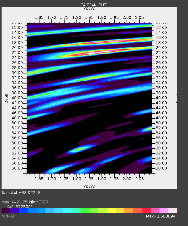
| Estimated Moho Depth: |
21.75 km |
| Estimated Crust Vp/Vs: |
1.87 |
| Assumed Crust Vp: |
6.522 km/s |
| Estimated Crust Vs: |
3.483 km/s |
| Estimated Crust Poisson's Ratio: |
0.30 |
|
| Radial Match: |
88.02248 % |
| Radial Bump: |
400 |
| Transverse Match: |
88.233444 % |
| Transverse Bump: |
400 |
| SOD ConfigId: |
21709731 |
| Insert Time: |
2020-09-01 00:16:18.971 +0000 |
| GWidth: |
2.5 |
| Max Bumps: |
400 |
| Tol: |
0.001 |
|
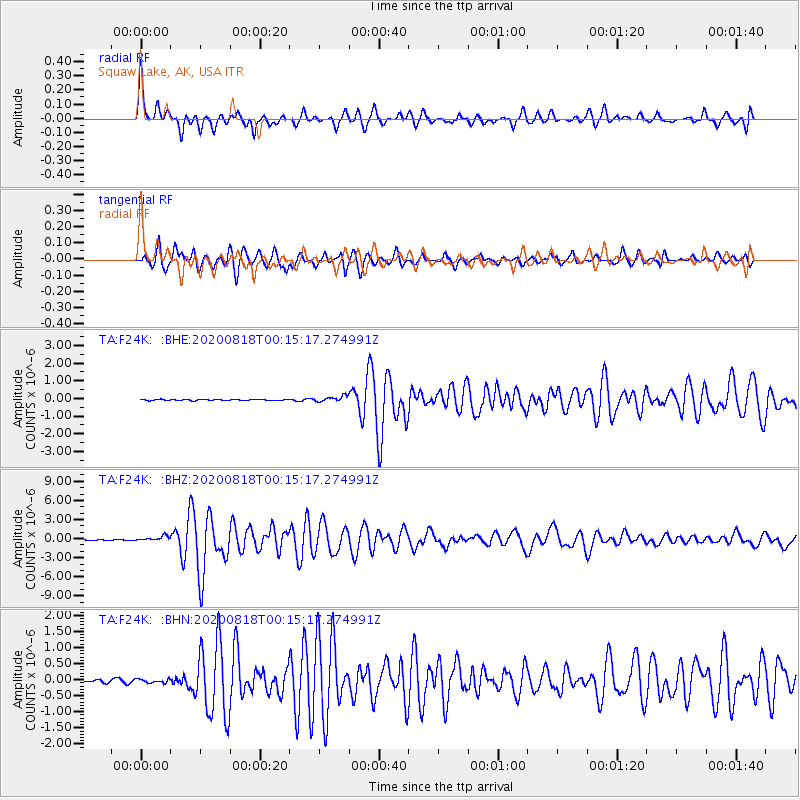
Signal To Noise
| Channel | StoN | STA | LTA |
| TA:F24K: :BHZ:20200818T00:15:17.274991Z | 5.9743543 | 3.88597E-7 | 6.504418E-8 |
| TA:F24K: :BHN:20200818T00:15:17.274991Z | 1.1431695 | 5.740389E-8 | 5.0214677E-8 |
| TA:F24K: :BHE:20200818T00:15:17.274991Z | 5.1828113 | 1.5146357E-7 | 2.922421E-8 |
| Arrivals |
| Ps | 3.0 SECOND |
| PpPs | 9.3 SECOND |
| PsPs/PpSs | 12 SECOND |


