You are here: Home > Network List > TA - USArray Transportable Network (new EarthScope stations) Stations List
> Station F31M Tsiigehtchic, NWT, CAN > Earthquake Result Viewer
F31M Tsiigehtchic, NWT, CAN - Earthquake Result Viewer
| Earthquake location: |
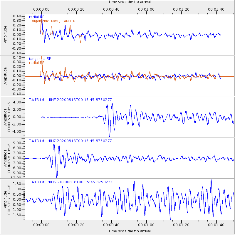
Samar, Philippines |
| Earthquake latitude/longitude: |
12.0/124.1 |
| Earthquake time(UTC): |
2020/08/18 (231) 00:03:48 GMT |
| Earthquake Depth: |
10 km |
| Earthquake Magnitude: |
6.7 mww |
| Earthquake Catalog/Contributor: |
NEIC PDE/us |
|
| Network: |
TA USArray Transportable Network (new EarthScope stations) |
| Station: |
F31M Tsiigehtchic, NWT, CAN |
| Lat/Lon: |
67.44 N/133.74 W |
| Elevation: |
56 m |
|
| Distance: |
83.6 deg |
| Az: |
22.306 deg |
| Baz: |
285.751 deg |
| Ray Param: |
0.04606903 |
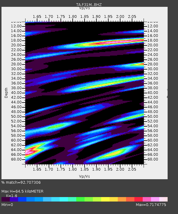
| Estimated Moho Depth: |
64.5 km |
| Estimated Crust Vp/Vs: |
1.60 |
| Assumed Crust Vp: |
6.171 km/s |
| Estimated Crust Vs: |
3.857 km/s |
| Estimated Crust Poisson's Ratio: |
0.18 |
|
| Radial Match: |
92.707306 % |
| Radial Bump: |
400 |
| Transverse Match: |
86.22107 % |
| Transverse Bump: |
394 |
| SOD ConfigId: |
21709731 |
| Insert Time: |
2020-09-01 00:16:25.853 +0000 |
| GWidth: |
2.5 |
| Max Bumps: |
400 |
| Tol: |
0.001 |
|
Signal To Noise
| Channel | StoN | STA | LTA |
| TA:F31M: :BHZ:20200818T00:15:45.875027Z | 9.465957 | 6.990485E-7 | 7.384868E-8 |
| TA:F31M: :BHN:20200818T00:15:45.875027Z | 1.1934689 | 1.1255934E-7 | 9.431275E-8 |
| TA:F31M: :BHE:20200818T00:15:45.875027Z | 3.3424509 | 2.286002E-7 | 6.8392985E-8 |
| Arrivals |
| Ps | 6.4 SECOND |
| PpPs | 26 SECOND |
| PsPs/PpSs | 33 SECOND |


