You are here: Home > Network List > TA - USArray Transportable Network (new EarthScope stations) Stations List
> Station G17K Kiwalik Mountain, AK, USA > Earthquake Result Viewer
G17K Kiwalik Mountain, AK, USA - Earthquake Result Viewer
| Earthquake location: |
Samar, Philippines |
| Earthquake latitude/longitude: |
12.0/124.1 |
| Earthquake time(UTC): |
2020/08/18 (231) 00:03:48 GMT |
| Earthquake Depth: |
10 km |
| Earthquake Magnitude: |
6.7 mww |
| Earthquake Catalog/Contributor: |
NEIC PDE/us |
|
| Network: |
TA USArray Transportable Network (new EarthScope stations) |
| Station: |
G17K Kiwalik Mountain, AK, USA |
| Lat/Lon: |
65.50 N/160.65 W |
| Elevation: |
338 m |
|
| Distance: |
73.0 deg |
| Az: |
24.935 deg |
| Baz: |
261.564 deg |
| Ray Param: |
0.0532794 |
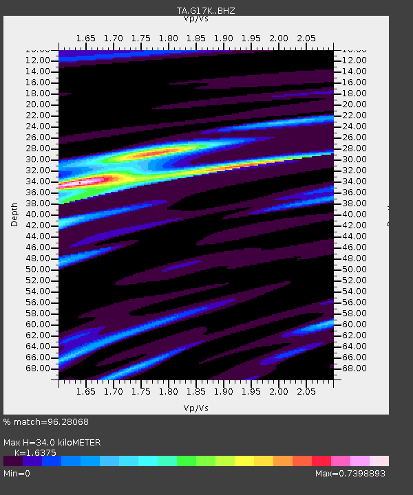
| Estimated Moho Depth: |
34.0 km |
| Estimated Crust Vp/Vs: |
1.64 |
| Assumed Crust Vp: |
6.276 km/s |
| Estimated Crust Vs: |
3.833 km/s |
| Estimated Crust Poisson's Ratio: |
0.20 |
|
| Radial Match: |
96.28068 % |
| Radial Bump: |
302 |
| Transverse Match: |
92.56638 % |
| Transverse Bump: |
397 |
| SOD ConfigId: |
21709731 |
| Insert Time: |
2020-09-01 00:16:29.477 +0000 |
| GWidth: |
2.5 |
| Max Bumps: |
400 |
| Tol: |
0.001 |
|

Signal To Noise
| Channel | StoN | STA | LTA |
| TA:G17K: :BHZ:20200818T00:14:47.574979Z | 10.4461775 | 4.710244E-7 | 4.50906E-8 |
| TA:G17K: :BHN:20200818T00:14:47.574979Z | 0.48115575 | 2.9141189E-8 | 6.056498E-8 |
| TA:G17K: :BHE:20200818T00:14:47.574979Z | 3.6737564 | 1.8400263E-7 | 5.0085692E-8 |
| Arrivals |
| Ps | 3.6 SECOND |
| PpPs | 14 SECOND |
| PsPs/PpSs | 17 SECOND |


