You are here: Home > Network List > TA - USArray Transportable Network (new EarthScope stations) Stations List
> Station G19K Purcell Mountains, AK, USA > Earthquake Result Viewer
G19K Purcell Mountains, AK, USA - Earthquake Result Viewer
| Earthquake location: |
Samar, Philippines |
| Earthquake latitude/longitude: |
12.0/124.1 |
| Earthquake time(UTC): |
2020/08/18 (231) 00:03:48 GMT |
| Earthquake Depth: |
10 km |
| Earthquake Magnitude: |
6.7 mww |
| Earthquake Catalog/Contributor: |
NEIC PDE/us |
|
| Network: |
TA USArray Transportable Network (new EarthScope stations) |
| Station: |
G19K Purcell Mountains, AK, USA |
| Lat/Lon: |
66.14 N/157.09 W |
| Elevation: |
391 m |
|
| Distance: |
74.6 deg |
| Az: |
24.451 deg |
| Baz: |
264.677 deg |
| Ray Param: |
0.052257042 |
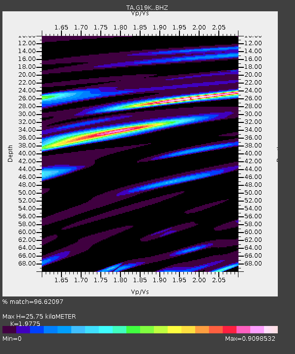
| Estimated Moho Depth: |
25.75 km |
| Estimated Crust Vp/Vs: |
1.98 |
| Assumed Crust Vp: |
6.577 km/s |
| Estimated Crust Vs: |
3.326 km/s |
| Estimated Crust Poisson's Ratio: |
0.33 |
|
| Radial Match: |
96.62097 % |
| Radial Bump: |
363 |
| Transverse Match: |
92.048965 % |
| Transverse Bump: |
353 |
| SOD ConfigId: |
21709731 |
| Insert Time: |
2020-09-01 00:16:32.100 +0000 |
| GWidth: |
2.5 |
| Max Bumps: |
400 |
| Tol: |
0.001 |
|

Signal To Noise
| Channel | StoN | STA | LTA |
| TA:G19K: :BHZ:20200818T00:14:56.550015Z | 7.377743 | 4.757713E-7 | 6.4487374E-8 |
| TA:G19K: :BHN:20200818T00:14:56.550015Z | 1.3112851 | 6.9475526E-8 | 5.2982777E-8 |
| TA:G19K: :BHE:20200818T00:14:56.550015Z | 4.26271 | 2.0402763E-7 | 4.7863363E-8 |
| Arrivals |
| Ps | 3.9 SECOND |
| PpPs | 11 SECOND |
| PsPs/PpSs | 15 SECOND |


