You are here: Home > Network List > TA - USArray Transportable Network (new EarthScope stations) Stations List
> Station G23K Bananza Creek, AK, USA > Earthquake Result Viewer
G23K Bananza Creek, AK, USA - Earthquake Result Viewer
| Earthquake location: |
Samar, Philippines |
| Earthquake latitude/longitude: |
12.0/124.1 |
| Earthquake time(UTC): |
2020/08/18 (231) 00:03:48 GMT |
| Earthquake Depth: |
10 km |
| Earthquake Magnitude: |
6.7 mww |
| Earthquake Catalog/Contributor: |
NEIC PDE/us |
|
| Network: |
TA USArray Transportable Network (new EarthScope stations) |
| Station: |
G23K Bananza Creek, AK, USA |
| Lat/Lon: |
66.71 N/150.02 W |
| Elevation: |
746 m |
|
| Distance: |
77.4 deg |
| Az: |
23.975 deg |
| Baz: |
271.03 deg |
| Ray Param: |
0.050334226 |
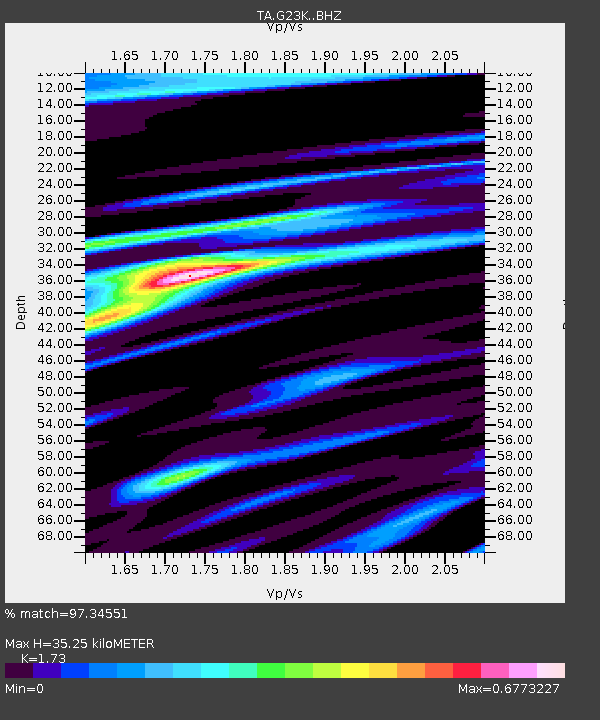
| Estimated Moho Depth: |
35.25 km |
| Estimated Crust Vp/Vs: |
1.73 |
| Assumed Crust Vp: |
6.577 km/s |
| Estimated Crust Vs: |
3.802 km/s |
| Estimated Crust Poisson's Ratio: |
0.25 |
|
| Radial Match: |
97.34551 % |
| Radial Bump: |
301 |
| Transverse Match: |
95.60676 % |
| Transverse Bump: |
347 |
| SOD ConfigId: |
21709731 |
| Insert Time: |
2020-09-01 00:16:34.495 +0000 |
| GWidth: |
2.5 |
| Max Bumps: |
400 |
| Tol: |
0.001 |
|

Signal To Noise
| Channel | StoN | STA | LTA |
| TA:G23K: :BHZ:20200818T00:15:12.800015Z | 9.778168 | 4.399396E-7 | 4.4992028E-8 |
| TA:G23K: :BHN:20200818T00:15:12.800015Z | 1.2726169 | 5.85587E-8 | 4.6014396E-8 |
| TA:G23K: :BHE:20200818T00:15:12.800015Z | 5.825689 | 1.9927076E-7 | 3.420553E-8 |
| Arrivals |
| Ps | 4.0 SECOND |
| PpPs | 14 SECOND |
| PsPs/PpSs | 18 SECOND |


