You are here: Home > Network List > TA - USArray Transportable Network (new EarthScope stations) Stations List
> Station G30M túh Zraii Njik, YT, CAN > Earthquake Result Viewer
G30M túh Zraii Njik, YT, CAN - Earthquake Result Viewer
| Earthquake location: |
Samar, Philippines |
| Earthquake latitude/longitude: |
12.0/124.1 |
| Earthquake time(UTC): |
2020/08/18 (231) 00:03:48 GMT |
| Earthquake Depth: |
10 km |
| Earthquake Magnitude: |
6.7 mww |
| Earthquake Catalog/Contributor: |
NEIC PDE/us |
|
| Network: |
TA USArray Transportable Network (new EarthScope stations) |
| Station: |
G30M túh Zraii Njik, YT, CAN |
| Lat/Lon: |
66.98 N/136.22 W |
| Elevation: |
739 m |
|
| Distance: |
82.8 deg |
| Az: |
23.002 deg |
| Baz: |
283.55 deg |
| Ray Param: |
0.046646163 |
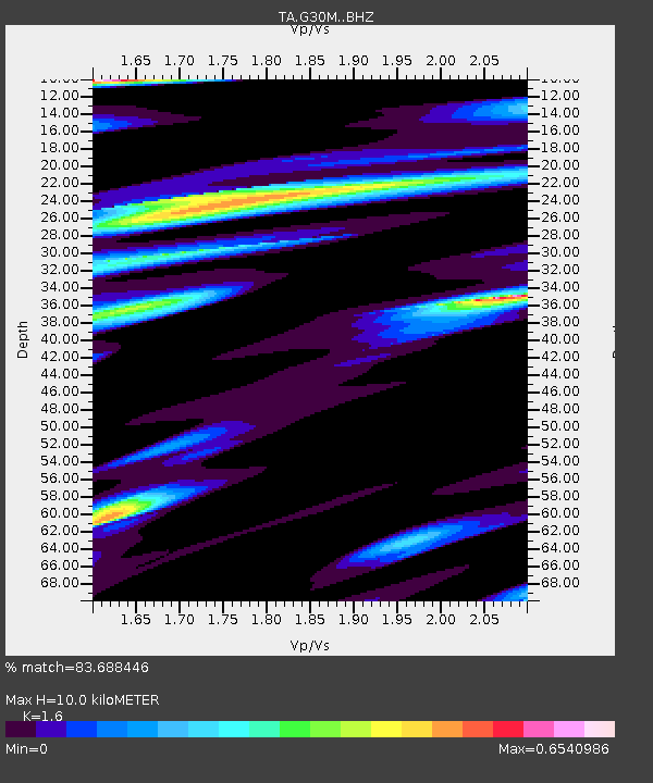
| Estimated Moho Depth: |
10.0 km |
| Estimated Crust Vp/Vs: |
1.60 |
| Assumed Crust Vp: |
6.522 km/s |
| Estimated Crust Vs: |
4.076 km/s |
| Estimated Crust Poisson's Ratio: |
0.18 |
|
| Radial Match: |
83.688446 % |
| Radial Bump: |
400 |
| Transverse Match: |
84.607666 % |
| Transverse Bump: |
378 |
| SOD ConfigId: |
21709731 |
| Insert Time: |
2020-09-01 00:16:42.360 +0000 |
| GWidth: |
2.5 |
| Max Bumps: |
400 |
| Tol: |
0.001 |
|

Signal To Noise
| Channel | StoN | STA | LTA |
| TA:G30M: :BHZ:20200818T00:15:41.675015Z | 4.555923 | 6.1138127E-7 | 1.3419482E-7 |
| TA:G30M: :BHN:20200818T00:15:41.675015Z | 1.4432315 | 1.3989879E-7 | 9.69344E-8 |
| TA:G30M: :BHE:20200818T00:15:41.675015Z | 2.3915422 | 1.894557E-7 | 7.921905E-8 |
| Arrivals |
| Ps | 0.9 SECOND |
| PpPs | 3.9 SECOND |
| PsPs/PpSs | 4.8 SECOND |


