You are here: Home > Network List > TA - USArray Transportable Network (new EarthScope stations) Stations List
> Station H29M Whitestone, YT, CAN > Earthquake Result Viewer
H29M Whitestone, YT, CAN - Earthquake Result Viewer
| Earthquake location: |
Samar, Philippines |
| Earthquake latitude/longitude: |
12.0/124.1 |
| Earthquake time(UTC): |
2020/08/18 (231) 00:03:48 GMT |
| Earthquake Depth: |
10 km |
| Earthquake Magnitude: |
6.7 mww |
| Earthquake Catalog/Contributor: |
NEIC PDE/us |
|
| Network: |
TA USArray Transportable Network (new EarthScope stations) |
| Station: |
H29M Whitestone, YT, CAN |
| Lat/Lon: |
66.22 N/138.37 W |
| Elevation: |
480 m |
|
| Distance: |
82.1 deg |
| Az: |
23.944 deg |
| Baz: |
281.705 deg |
| Ray Param: |
0.047107972 |
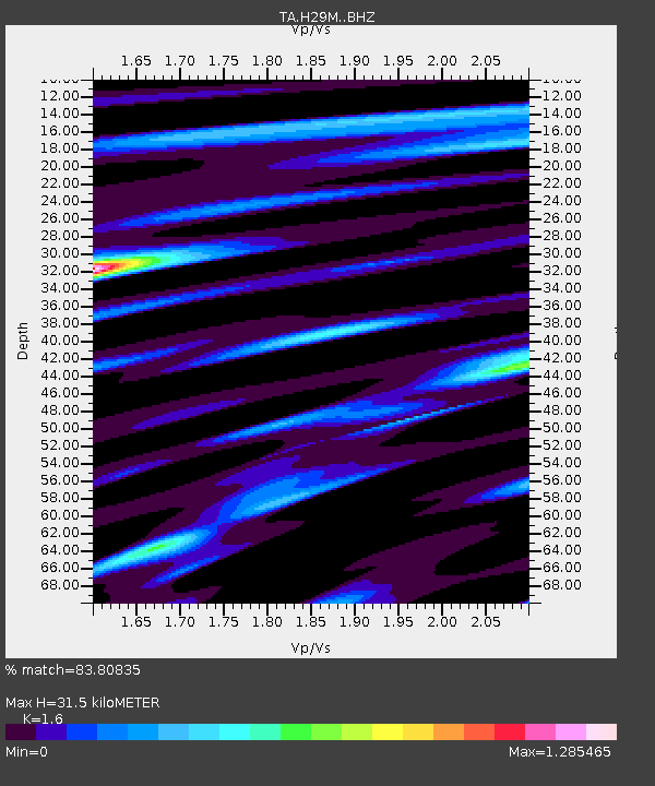
| Estimated Moho Depth: |
31.5 km |
| Estimated Crust Vp/Vs: |
1.60 |
| Assumed Crust Vp: |
6.577 km/s |
| Estimated Crust Vs: |
4.11 km/s |
| Estimated Crust Poisson's Ratio: |
0.18 |
|
| Radial Match: |
83.80835 % |
| Radial Bump: |
400 |
| Transverse Match: |
82.033745 % |
| Transverse Bump: |
400 |
| SOD ConfigId: |
21709731 |
| Insert Time: |
2020-09-01 00:16:53.156 +0000 |
| GWidth: |
2.5 |
| Max Bumps: |
400 |
| Tol: |
0.001 |
|

Signal To Noise
| Channel | StoN | STA | LTA |
| TA:H29M: :BHZ:20200818T00:15:38.175015Z | 3.399014 | 4.4837915E-7 | 1.3191448E-7 |
| TA:H29M: :BHN:20200818T00:15:38.175015Z | 1.6275283 | 1.7823102E-7 | 1.0951024E-7 |
| TA:H29M: :BHE:20200818T00:15:38.175015Z | 1.1344308 | 1.6638232E-7 | 1.4666591E-7 |
| Arrivals |
| Ps | 3.0 SECOND |
| PpPs | 12 SECOND |
| PsPs/PpSs | 15 SECOND |


