You are here: Home > Network List > TA - USArray Transportable Network (new EarthScope stations) Stations List
> Station H31M Peel River, Yukon, CAN > Earthquake Result Viewer
H31M Peel River, Yukon, CAN - Earthquake Result Viewer
| Earthquake location: |
Samar, Philippines |
| Earthquake latitude/longitude: |
12.0/124.1 |
| Earthquake time(UTC): |
2020/08/18 (231) 00:03:48 GMT |
| Earthquake Depth: |
10 km |
| Earthquake Magnitude: |
6.7 mww |
| Earthquake Catalog/Contributor: |
NEIC PDE/us |
|
| Network: |
TA USArray Transportable Network (new EarthScope stations) |
| Station: |
H31M Peel River, Yukon, CAN |
| Lat/Lon: |
65.81 N/134.34 W |
| Elevation: |
642 m |
|
| Distance: |
83.8 deg |
| Az: |
23.963 deg |
| Baz: |
285.382 deg |
| Ray Param: |
0.045917667 |
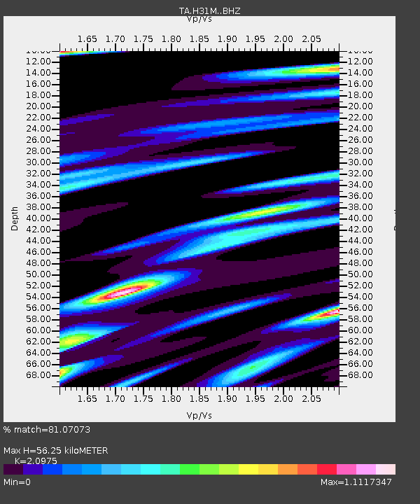
| Estimated Moho Depth: |
56.25 km |
| Estimated Crust Vp/Vs: |
2.10 |
| Assumed Crust Vp: |
6.419 km/s |
| Estimated Crust Vs: |
3.06 km/s |
| Estimated Crust Poisson's Ratio: |
0.35 |
|
| Radial Match: |
81.07073 % |
| Radial Bump: |
289 |
| Transverse Match: |
70.19835 % |
| Transverse Bump: |
385 |
| SOD ConfigId: |
21709731 |
| Insert Time: |
2020-09-01 00:16:53.844 +0000 |
| GWidth: |
2.5 |
| Max Bumps: |
400 |
| Tol: |
0.001 |
|
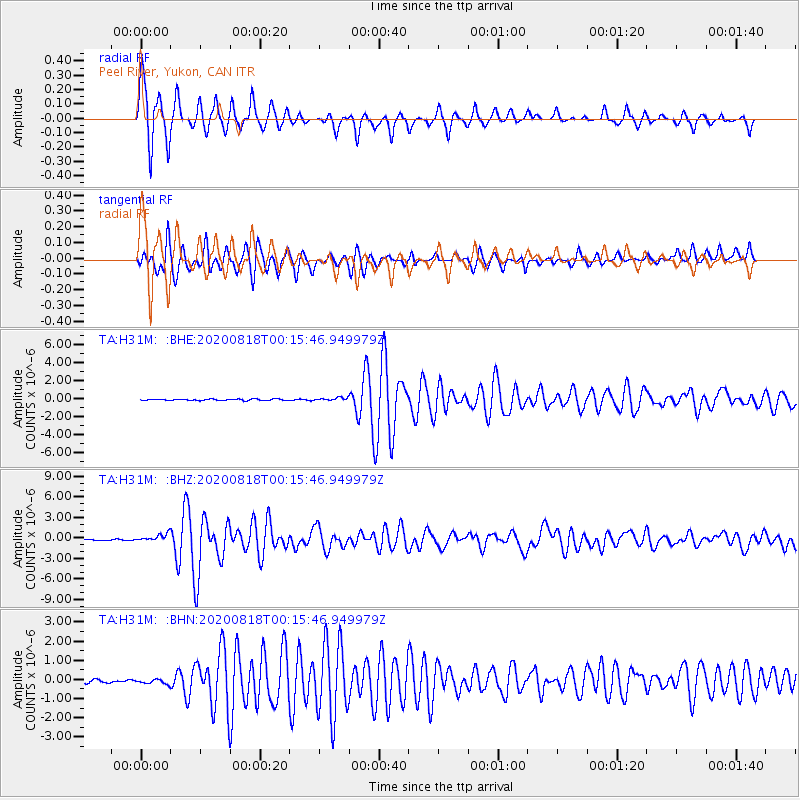
Signal To Noise
| Channel | StoN | STA | LTA |
| TA:H31M: :BHZ:20200818T00:15:46.949979Z | 8.257707 | 5.891423E-7 | 7.134454E-8 |
| TA:H31M: :BHN:20200818T00:15:46.949979Z | 1.1694479 | 1.230549E-7 | 1.05224785E-7 |
| TA:H31M: :BHE:20200818T00:15:46.949979Z | 2.1916828 | 1.6791758E-7 | 7.661583E-8 |
| Arrivals |
| Ps | 9.8 SECOND |
| PpPs | 27 SECOND |
| PsPs/PpSs | 36 SECOND |


